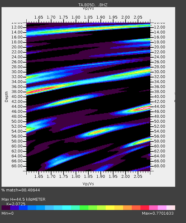
B05D Stanwood, WA, USA - Earthquake Result Viewer

Earthquake location: Off East Coast Of Honshu, Japan
Earthquake latitude/longitude: 34.9/141.1
Earthquake time(UTC): 2012/06/05 (157) 19:31:33 GMT
Earthquake Depth: 15 km
Earthquake Magnitude: 6.2 MB, 6.0 MS, 6.1 MW, 6.1 MW
Earthquake Catalog/Contributor: WHDF/NEIC
Network: TA USArray Transportable Network (new EarthScope stations)
Station: B05D Stanwood, WA, USA
Lat/Lon: 48.26 N/122.10 W
Elevation: 153 m
Distance: 68.9 deg
Az: 45.321 deg
Baz: 299.046 deg
Ray Param: 0.055970646
Estimated Moho Depth: 44.5 km
Estimated Crust Vp/Vs: 2.07
Assumed Crust Vp: 6.566 km/s
Estimated Crust Vs: 3.168 km/s
Estimated Crust Poisson's Ratio: 0.35
Radial Match: 88.48644 %
Radial Bump: 400
Transverse Match: 84.782425 %
Transverse Bump: 400
SOD ConfigId: 458385
Insert Time: 2012-10-16 10:19:25.658 +0000
GWidth: 2.5
Max Bumps: 400
Tol: 0.001

Signal To Noise

ChannelStoNSTALTA
TA:B05D: :BHZ:20120605T19:42:06.775024Z8.834451.2526219E-61.4178833E-7
TA:B05D: :BHN:20120605T19:42:06.775024Z2.5300853.0116675E-71.1903423E-7
TA:B05D: :BHE:20120605T19:42:06.775024Z4.23491764.599014E-71.0859748E-7
Arrivals
Ps7.5 SECOND
PpPs20 SECOND
PsPs/PpSs28 SECOND