You are here: Home > Network List > TA - USArray Transportable Network (new EarthScope stations) Stations List
> Station D33A AnnSam, Waubun, MN, USA > Earthquake Result Viewer
D33A AnnSam, Waubun, MN, USA - Earthquake Result Viewer

| Earthquake location: |
Off East Coast Of Honshu, Japan |
| Earthquake latitude/longitude: |
34.9/141.1 |
| Earthquake time(UTC): |
2012/06/05 (157) 19:31:33 GMT |
| Earthquake Depth: |
15 km |
| Earthquake Magnitude: |
6.2 MB, 6.0 MS, 6.1 MW, 6.1 MW |
| Earthquake Catalog/Contributor: |
WHDF/NEIC |
|
| Network: |
TA USArray Transportable Network (new EarthScope stations) |
| Station: |
D33A AnnSam, Waubun, MN, USA |
| Lat/Lon: |
47.14 N/95.84 W |
| Elevation: |
466 m |
|
| Distance: |
83.6 deg |
| Az: |
35.165 deg |
| Baz: |
316.125 deg |
| Ray Param: |
0.046045426 |
| Estimated Moho Depth: |
25.75 km |
| Estimated Crust Vp/Vs: |
1.84 |
| Assumed Crust Vp: |
6.419 km/s |
| Estimated Crust Vs: |
3.498 km/s |
| Estimated Crust Poisson's Ratio: |
0.29 |
|
| Radial Match: |
80.80952 % |
| Radial Bump: |
400 |
| Transverse Match: |
79.463806 % |
| Transverse Bump: |
400 |
| SOD ConfigId: |
458385 |
| Insert Time: |
2012-10-16 10:20:57.002 +0000 |
| GWidth: |
2.5 |
| Max Bumps: |
400 |
| Tol: |
0.001 |
|
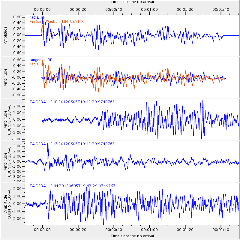
Signal To Noise
| Channel | StoN | STA | LTA |
| TA:D33A: :BHZ:20120605T19:43:29.974976Z | 7.614814 | 1.2464109E-6 | 1.6368239E-7 |
| TA:D33A: :BHN:20120605T19:43:29.974976Z | 4.498821 | 7.0875086E-7 | 1.5754148E-7 |
| TA:D33A: :BHE:20120605T19:43:29.974976Z | 3.4236126 | 6.46935E-7 | 1.8896267E-7 |
| Arrivals |
| Ps | 3.4 SECOND |
| PpPs | 11 SECOND |
| PsPs/PpSs | 15 SECOND |


