You are here: Home > Network List > G - GEOSCOPE Stations List
> Station SEY Seymchan, URSS > Earthquake Result Viewer
SEY Seymchan, URSS - Earthquake Result Viewer
| Earthquake location: |
Minahassa Peninsula, Sulawesi |
| Earthquake latitude/longitude: |
1.1/124.0 |
| Earthquake time(UTC): |
1992/06/06 (158) 21:40:41 GMT |
| Earthquake Depth: |
25 km |
| Earthquake Magnitude: |
5.8 MB, 5.6 MS |
| Earthquake Catalog/Contributor: |
WHDF/NEIC |
|
| Network: |
G GEOSCOPE |
| Station: |
SEY Seymchan, URSS |
| Lat/Lon: |
62.93 N/152.37 E |
| Elevation: |
206 m |
|
| Distance: |
65.2 deg |
| Az: |
13.864 deg |
| Baz: |
211.582 deg |
| Ray Param: |
0.058367178 |
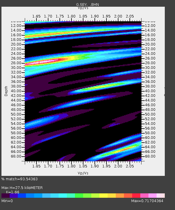
| Estimated Moho Depth: |
27.5 km |
| Estimated Crust Vp/Vs: |
1.66 |
| Assumed Crust Vp: |
6.577 km/s |
| Estimated Crust Vs: |
3.962 km/s |
| Estimated Crust Poisson's Ratio: |
0.22 |
|
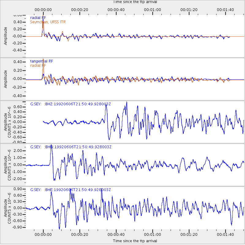
| Radial Match: |
93.54363 % |
| Radial Bump: |
400 |
| Transverse Match: |
92.16022 % |
| Transverse Bump: |
400 |
| SOD ConfigId: |
4480 |
| Insert Time: |
2010-02-26 23:59:43.692 +0000 |
| GWidth: |
2.5 |
| Max Bumps: |
400 |
| Tol: |
0.001 |
|
Signal To Noise
| Channel | StoN | STA | LTA |
| G:SEY: :BHN:19920606T21:50:49.928003Z | 18.016573 | 9.929081E-7 | 5.511082E-8 |
| G:SEY: :BHE:19920606T21:50:49.928003Z | 7.6979065 | 2.6697202E-7 | 3.4681122E-8 |
| G:SEY: :BHZ:19920606T21:50:49.928003Z | 5.266951 | 2.50778E-7 | 4.76135E-8 |
| Arrivals |
| Ps | 2.9 SECOND |
| PpPs | 11 SECOND |
| PsPs/PpSs | 14 SECOND |


