You are here: Home > Network List > TA - USArray Transportable Network (new EarthScope stations) Stations List
> Station O03E Paynes Creek, CA, USA > Earthquake Result Viewer
O03E Paynes Creek, CA, USA - Earthquake Result Viewer
| Earthquake location: |
Central East Pacific Rise |
| Earthquake latitude/longitude: |
-4.5/-106.0 |
| Earthquake time(UTC): |
2014/05/18 (138) 23:47:04 GMT |
| Earthquake Depth: |
17 km |
| Earthquake Magnitude: |
5.9 MW |
| Earthquake Catalog/Contributor: |
ISC/ISC |
|
| Network: |
TA USArray Transportable Network (new EarthScope stations) |
| Station: |
O03E Paynes Creek, CA, USA |
| Lat/Lon: |
40.29 N/121.80 W |
| Elevation: |
967 m |
|
| Distance: |
46.8 deg |
| Az: |
343.428 deg |
| Baz: |
158.174 deg |
| Ray Param: |
0.07037588 |
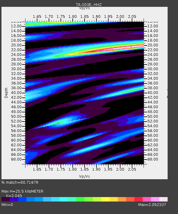
| Estimated Moho Depth: |
20.5 km |
| Estimated Crust Vp/Vs: |
2.05 |
| Assumed Crust Vp: |
6.566 km/s |
| Estimated Crust Vs: |
3.211 km/s |
| Estimated Crust Poisson's Ratio: |
0.34 |
|
| Radial Match: |
80.71679 % |
| Radial Bump: |
400 |
| Transverse Match: |
59.95953 % |
| Transverse Bump: |
400 |
| SOD ConfigId: |
3390531 |
| Insert Time: |
2019-04-11 23:09:25.845 +0000 |
| GWidth: |
2.5 |
| Max Bumps: |
400 |
| Tol: |
0.001 |
|
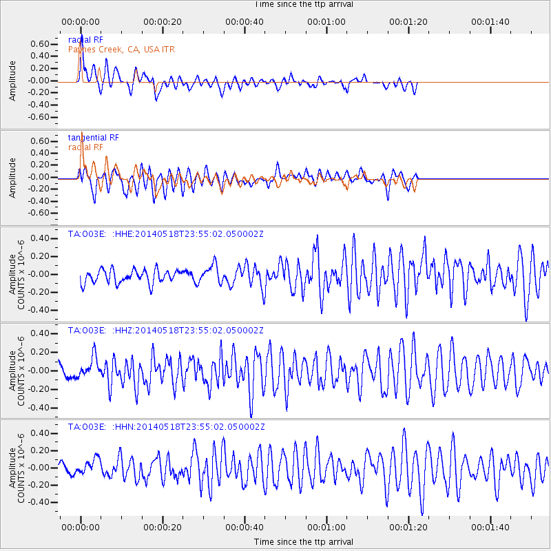
Signal To Noise
| Channel | StoN | STA | LTA |
| TA:O03E: :HHZ:20140518T23:55:02.050002Z | 2.3532376 | 1.1612172E-7 | 4.9345513E-8 |
| TA:O03E: :HHN:20140518T23:55:02.050002Z | 1.5660398 | 1.03972454E-7 | 6.639196E-8 |
| TA:O03E: :HHE:20140518T23:55:02.050002Z | 1.414692 | 1.03324815E-7 | 7.3036965E-8 |
| Arrivals |
| Ps | 3.5 SECOND |
| PpPs | 9.0 SECOND |
| PsPs/PpSs | 12 SECOND |


