You are here: Home > Network List > G - GEOSCOPE Stations List
> Station SEY Seymchan, URSS > Earthquake Result Viewer
SEY Seymchan, URSS - Earthquake Result Viewer
| Earthquake location: |
Minahassa Peninsula, Sulawesi |
| Earthquake latitude/longitude: |
1.1/124.1 |
| Earthquake time(UTC): |
1992/06/11 (163) 02:03:36 GMT |
| Earthquake Depth: |
34 km |
| Earthquake Magnitude: |
5.7 MB, 5.2 MS |
| Earthquake Catalog/Contributor: |
WHDF/NEIC |
|
| Network: |
G GEOSCOPE |
| Station: |
SEY Seymchan, URSS |
| Lat/Lon: |
62.93 N/152.37 E |
| Elevation: |
206 m |
|
| Distance: |
65.2 deg |
| Az: |
13.795 deg |
| Baz: |
211.409 deg |
| Ray Param: |
0.058383867 |
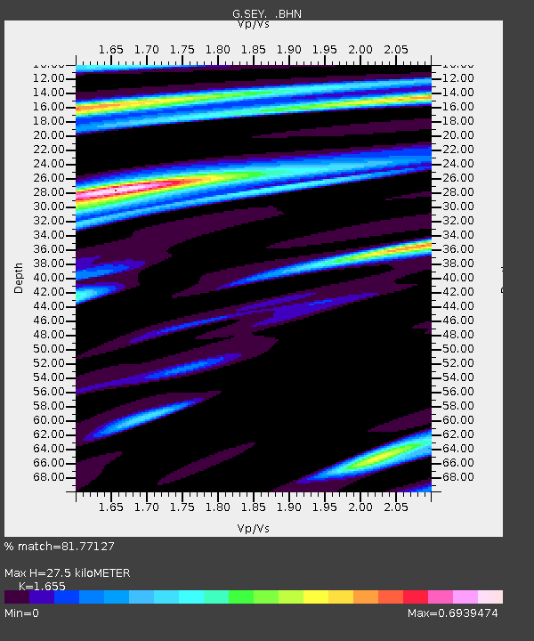
| Estimated Moho Depth: |
27.5 km |
| Estimated Crust Vp/Vs: |
1.65 |
| Assumed Crust Vp: |
6.577 km/s |
| Estimated Crust Vs: |
3.974 km/s |
| Estimated Crust Poisson's Ratio: |
0.21 |
|
| Radial Match: |
81.77127 % |
| Radial Bump: |
400 |
| Transverse Match: |
63.34864 % |
| Transverse Bump: |
400 |
| SOD ConfigId: |
4480 |
| Insert Time: |
2010-02-26 23:59:47.780 +0000 |
| GWidth: |
2.5 |
| Max Bumps: |
400 |
| Tol: |
0.001 |
|
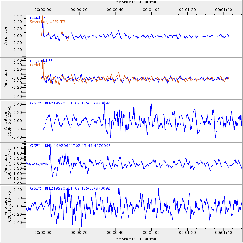
Signal To Noise
| Channel | StoN | STA | LTA |
| G:SEY: :BHN:19920611T02:13:43.497009Z | 7.915883 | 5.702518E-7 | 7.2038944E-8 |
| G:SEY: :BHE:19920611T02:13:43.497009Z | 2.4895518 | 1.517584E-7 | 6.095812E-8 |
| G:SEY: :BHZ:19920611T02:13:43.497009Z | 1.5538231 | 1.5222457E-7 | 9.7967764E-8 |
| Arrivals |
| Ps | 2.9 SECOND |
| PpPs | 11 SECOND |
| PsPs/PpSs | 13 SECOND |


