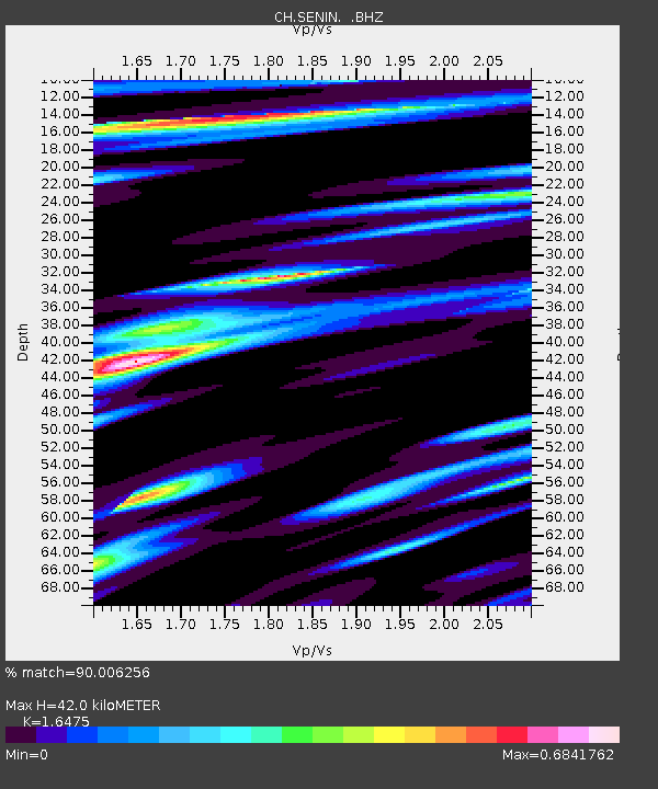
SENIN Lac Selin/Sanetsch - Earthquake Result Viewer

Earthquake location: Near East Coast Of Honshu, Japan
Earthquake latitude/longitude: 38.9/141.8
Earthquake time(UTC): 2012/06/17 (169) 20:32:20 GMT
Earthquake Depth: 36 km
Earthquake Magnitude: 6.0 MB, 5.9 MS, 6.3 MW, 6.4 MW
Earthquake Catalog/Contributor: WHDF/NEIC
Network: CH Switzerland Seismological Network
Station: SENIN Lac Selin/Sanetsch
Lat/Lon: 46.36 N/7.30 E
Elevation: 2035 m
Distance: 85.8 deg
Az: 330.333 deg
Baz: 33.888 deg
Ray Param: 0.04442605
Estimated Moho Depth: 42.0 km
Estimated Crust Vp/Vs: 1.65
Assumed Crust Vp: 6.276 km/s
Estimated Crust Vs: 3.809 km/s
Estimated Crust Poisson's Ratio: 0.21
Radial Match: 90.006256 %
Radial Bump: 400
Transverse Match: 86.45651 %
Transverse Bump: 400
SOD ConfigId: 460165
Insert Time: 2013-02-11 20:53:29.064 +0000
GWidth: 2.5
Max Bumps: 400
Tol: 0.001

Signal To Noise

ChannelStoNSTALTA
CH:SENIN: :BHZ:20120617T20:44:25.292026Z11.8978359.969116E-78.3789324E-8
CH:SENIN: :BHN:20120617T20:44:25.293003Z7.9762983.5458763E-74.4455163E-8
CH:SENIN: :BHE:20120617T20:44:25.275974Z6.7378812.3751971E-73.5251393E-8
Arrivals
Ps4.4 SECOND
PpPs17 SECOND
PsPs/PpSs22 SECOND