You are here: Home > Network List > CI - Caltech Regional Seismic Network Stations List
> Station SMM Simmler, CA, USA > Earthquake Result Viewer
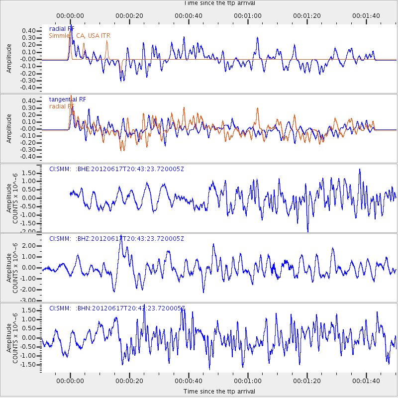
SMM Simmler, CA, USA - Earthquake Result Viewer
*The percent match for this event was below the threshold and hence no stack was calculated.
| Earthquake location: |
Near East Coast Of Honshu, Japan |
| Earthquake latitude/longitude: |
38.9/141.8 |
| Earthquake time(UTC): |
2012/06/17 (169) 20:32:20 GMT |
| Earthquake Depth: |
36 km |
| Earthquake Magnitude: |
6.0 MB, 5.9 MS, 6.3 MW, 6.4 MW |
| Earthquake Catalog/Contributor: |
WHDF/NEIC |
|
| Network: |
CI Caltech Regional Seismic Network |
| Station: |
SMM Simmler, CA, USA |
| Lat/Lon: |
35.31 N/120.00 W |
| Elevation: |
599 m |
|
| Distance: |
74.4 deg |
| Az: |
57.201 deg |
| Baz: |
306.697 deg |
| Ray Param: |
$rayparam |
*The percent match for this event was below the threshold and hence was not used in the summary stack. |
|
| Radial Match: |
70.06368 % |
| Radial Bump: |
400 |
| Transverse Match: |
58.302876 % |
| Transverse Bump: |
400 |
| SOD ConfigId: |
460165 |
| Insert Time: |
2013-02-11 20:56:16.262 +0000 |
| GWidth: |
2.5 |
| Max Bumps: |
400 |
| Tol: |
0.001 |
|
Signal To Noise
| Channel | StoN | STA | LTA |
| CI:SMM: :BHZ:20120617T20:43:23.720005Z | 4.283307 | 5.9028946E-7 | 1.3781161E-7 |
| CI:SMM: :BHN:20120617T20:43:23.720005Z | 1.3501173 | 4.6668998E-7 | 3.4566625E-7 |
| CI:SMM: :BHE:20120617T20:43:23.720005Z | 1.4189284 | 5.4544523E-7 | 3.8440646E-7 |
| Arrivals |
| Ps | |
| PpPs | |
| PsPs/PpSs | |


