You are here: Home > Network List > G - GEOSCOPE Stations List
> Station SEY Seymchan, URSS > Earthquake Result Viewer
SEY Seymchan, URSS - Earthquake Result Viewer
| Earthquake location: |
Bonin Islands, Japan Region |
| Earthquake latitude/longitude: |
28.0/139.3 |
| Earthquake time(UTC): |
1992/01/20 (020) 13:37:04 GMT |
| Earthquake Depth: |
512 km |
| Earthquake Magnitude: |
5.8 MB, 6.0 UNKNOWN |
| Earthquake Catalog/Contributor: |
WHDF/NEIC |
|
| Network: |
G GEOSCOPE |
| Station: |
SEY Seymchan, URSS |
| Lat/Lon: |
62.93 N/152.37 E |
| Elevation: |
206 m |
|
| Distance: |
36.0 deg |
| Az: |
10.113 deg |
| Baz: |
199.848 deg |
| Ray Param: |
0.07447039 |
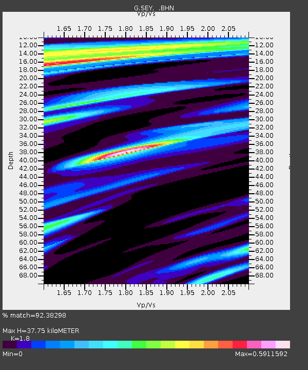
| Estimated Moho Depth: |
37.75 km |
| Estimated Crust Vp/Vs: |
1.80 |
| Assumed Crust Vp: |
6.577 km/s |
| Estimated Crust Vs: |
3.654 km/s |
| Estimated Crust Poisson's Ratio: |
0.28 |
|
| Radial Match: |
92.38298 % |
| Radial Bump: |
377 |
| Transverse Match: |
76.83508 % |
| Transverse Bump: |
400 |
| SOD ConfigId: |
16938 |
| Insert Time: |
2010-02-27 00:00:00.764 +0000 |
| GWidth: |
2.5 |
| Max Bumps: |
400 |
| Tol: |
0.001 |
|
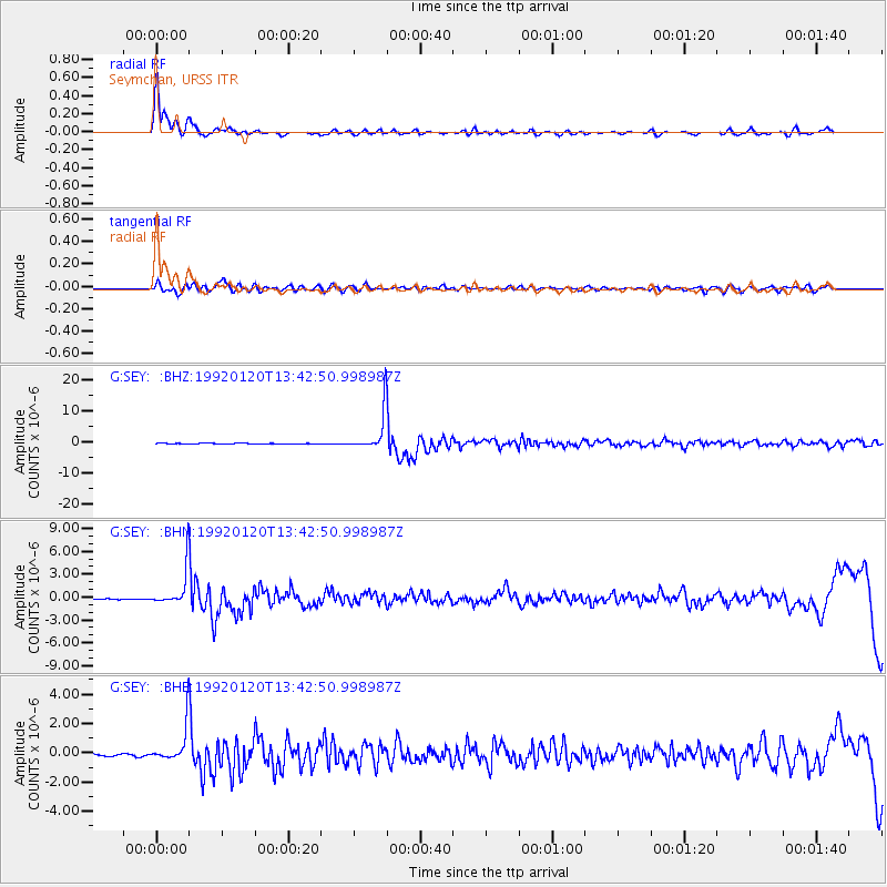
Signal To Noise
| Channel | StoN | STA | LTA |
| G:SEY: :BHN:19920120T13:42:50.998987Z | 46.14363 | 2.4918284E-6 | 5.4001568E-8 |
| G:SEY: :BHE:19920120T13:42:50.998987Z | 15.694851 | 1.263421E-6 | 8.049908E-8 |
| G:SEY: :BHZ:19920120T13:42:50.998987Z | 60.366367 | 6.1651303E-6 | 1.0212856E-7 |
| Arrivals |
| Ps | 4.9 SECOND |
| PpPs | 15 SECOND |
| PsPs/PpSs | 20 SECOND |


