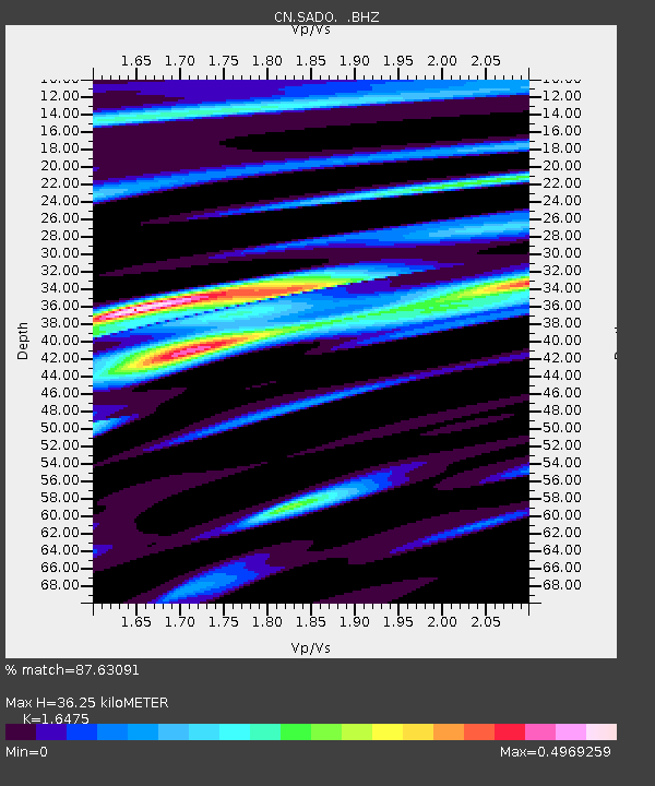
SADO SADOWA, ON - Earthquake Result Viewer
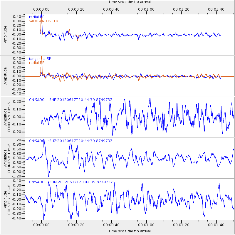
Earthquake location: Near East Coast Of Honshu, Japan
Earthquake latitude/longitude: 38.9/141.8
Earthquake time(UTC): 2012/06/17 (169) 20:32:20 GMT
Earthquake Depth: 36 km
Earthquake Magnitude: 6.0 MB, 5.9 MS, 6.3 MW, 6.4 MW
Earthquake Catalog/Contributor: WHDF/NEIC
Network: CN Canadian National Seismograph Network
Station: SADO SADOWA, ON
Lat/Lon: 44.77 N/79.14 W
Elevation: 243 m
Distance: 88.9 deg
Az: 27.849 deg
Baz: 329.229 deg
Ray Param: 0.042211533
Estimated Moho Depth: 36.25 km
Estimated Crust Vp/Vs: 1.65
Assumed Crust Vp: 6.577 km/s
Estimated Crust Vs: 3.992 km/s
Estimated Crust Poisson's Ratio: 0.21
Radial Match: 87.63091 %
Radial Bump: 384
Transverse Match: 62.701496 %
Transverse Bump: 400
SOD ConfigId: 460165
Insert Time: 2013-02-11 20:57:40.772 +0000
GWidth: 2.5
Max Bumps: 400
Tol: 0.001

Signal To Noise

ChannelStoNSTALTA
CN:SADO: :BHZ:20120617T20:44:39.874973Z6.91657076.950007E-71.0048343E-7
CN:SADO: :BHN:20120617T20:44:39.874973Z3.8643142.303928E-75.9620625E-8
CN:SADO: :BHE:20120617T20:44:39.874973Z2.79537751.3722267E-74.9089138E-8
Arrivals
Ps3.7 SECOND
PpPs14 SECOND
PsPs/PpSs18 SECOND