You are here: Home > Network List > G - GEOSCOPE Stations List
> Station SEY Seymchan, URSS > Earthquake Result Viewer
SEY Seymchan, URSS - Earthquake Result Viewer
| Earthquake location: |
Gulf Of Alaska |
| Earthquake latitude/longitude: |
57.6/-143.0 |
| Earthquake time(UTC): |
1992/08/07 (220) 18:19:19 GMT |
| Earthquake Depth: |
10 km |
| Earthquake Magnitude: |
6.3 MB, 6.5 MS, 6.5 ML |
| Earthquake Catalog/Contributor: |
WHDF/NEIC |
|
| Network: |
G GEOSCOPE |
| Station: |
SEY Seymchan, URSS |
| Lat/Lon: |
62.93 N/152.37 E |
| Elevation: |
206 m |
|
| Distance: |
31.2 deg |
| Az: |
307.166 deg |
| Baz: |
69.681 deg |
| Ray Param: |
0.07912375 |
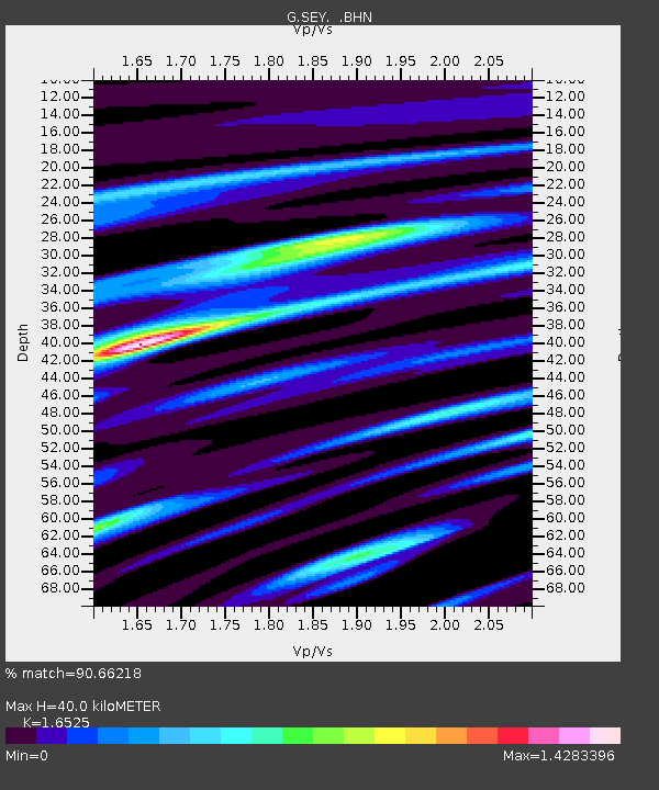
| Estimated Moho Depth: |
40.0 km |
| Estimated Crust Vp/Vs: |
1.65 |
| Assumed Crust Vp: |
6.577 km/s |
| Estimated Crust Vs: |
3.98 km/s |
| Estimated Crust Poisson's Ratio: |
0.21 |
|
| Radial Match: |
90.66218 % |
| Radial Bump: |
323 |
| Transverse Match: |
76.96573 % |
| Transverse Bump: |
400 |
| SOD ConfigId: |
16938 |
| Insert Time: |
2010-02-27 00:00:16.048 +0000 |
| GWidth: |
2.5 |
| Max Bumps: |
400 |
| Tol: |
0.001 |
|
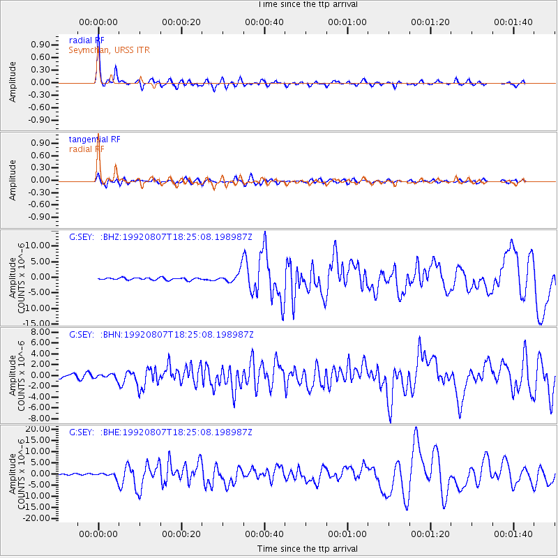
Signal To Noise
| Channel | StoN | STA | LTA |
| G:SEY: :BHN:19920807T18:25:08.198987Z | 1.755604 | 4.4543106E-7 | 2.5371955E-7 |
| G:SEY: :BHE:19920807T18:25:08.198987Z | 3.0125978 | 1.2542448E-6 | 4.163333E-7 |
| G:SEY: :BHZ:19920807T18:25:08.198987Z | 6.181747 | 2.1840071E-6 | 3.5329936E-7 |
| Arrivals |
| Ps | 4.3 SECOND |
| PpPs | 15 SECOND |
| PsPs/PpSs | 19 SECOND |


