You are here: Home > Network List > G - GEOSCOPE Stations List
> Station CLF Chambon la Foret observatory, France > Earthquake Result Viewer
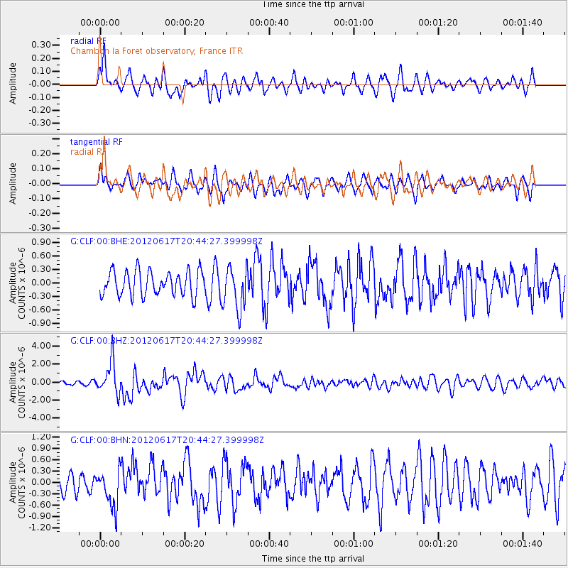
CLF Chambon la Foret observatory, France - Earthquake Result Viewer
*The percent match for this event was below the threshold and hence no stack was calculated.
| Earthquake location: |
Near East Coast Of Honshu, Japan |
| Earthquake latitude/longitude: |
38.9/141.8 |
| Earthquake time(UTC): |
2012/06/17 (169) 20:32:20 GMT |
| Earthquake Depth: |
36 km |
| Earthquake Magnitude: |
6.0 MB, 5.9 MS, 6.3 MW, 6.4 MW |
| Earthquake Catalog/Contributor: |
WHDF/NEIC |
|
| Network: |
G GEOSCOPE |
| Station: |
CLF Chambon la Foret observatory, France |
| Lat/Lon: |
48.03 N/2.26 E |
| Elevation: |
145 m |
|
| Distance: |
86.3 deg |
| Az: |
334.135 deg |
| Baz: |
30.462 deg |
| Ray Param: |
$rayparam |
*The percent match for this event was below the threshold and hence was not used in the summary stack. |
|
| Radial Match: |
68.76497 % |
| Radial Bump: |
380 |
| Transverse Match: |
55.97756 % |
| Transverse Bump: |
400 |
| SOD ConfigId: |
460165 |
| Insert Time: |
2013-02-11 20:58:55.086 +0000 |
| GWidth: |
2.5 |
| Max Bumps: |
400 |
| Tol: |
0.001 |
|
Signal To Noise
| Channel | StoN | STA | LTA |
| G:CLF:00:BHZ:20120617T20:44:27.399998Z | 7.957663 | 1.8424673E-6 | 2.3153372E-7 |
| G:CLF:00:BHN:20120617T20:44:27.399998Z | 1.8646322 | 5.056024E-7 | 2.7115394E-7 |
| G:CLF:00:BHE:20120617T20:44:27.399998Z | 1.7537034 | 4.7366353E-7 | 2.7009332E-7 |
| Arrivals |
| Ps | |
| PpPs | |
| PsPs/PpSs | |


