You are here: Home > Network List > G - GEOSCOPE Stations List
> Station SEY Seymchan, URSS > Earthquake Result Viewer
SEY Seymchan, URSS - Earthquake Result Viewer
| Earthquake location: |
Talaud Islands, Indonesia |
| Earthquake latitude/longitude: |
4.0/126.5 |
| Earthquake time(UTC): |
1992/08/09 (222) 19:49:43 GMT |
| Earthquake Depth: |
68 km |
| Earthquake Magnitude: |
6.1 MB |
| Earthquake Catalog/Contributor: |
WHDF/NEIC |
|
| Network: |
G GEOSCOPE |
| Station: |
SEY Seymchan, URSS |
| Lat/Lon: |
62.93 N/152.37 E |
| Elevation: |
206 m |
|
| Distance: |
61.8 deg |
| Az: |
13.087 deg |
| Baz: |
209.589 deg |
| Ray Param: |
0.06047415 |
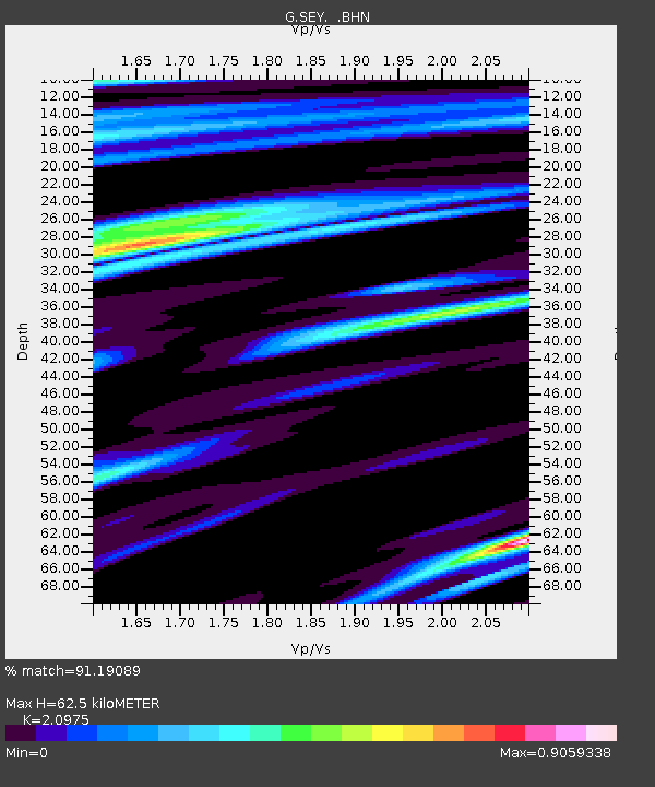
| Estimated Moho Depth: |
62.5 km |
| Estimated Crust Vp/Vs: |
2.10 |
| Assumed Crust Vp: |
6.577 km/s |
| Estimated Crust Vs: |
3.136 km/s |
| Estimated Crust Poisson's Ratio: |
0.35 |
|
| Radial Match: |
91.19089 % |
| Radial Bump: |
400 |
| Transverse Match: |
86.06066 % |
| Transverse Bump: |
400 |
| SOD ConfigId: |
16938 |
| Insert Time: |
2010-02-27 00:00:17.657 +0000 |
| GWidth: |
2.5 |
| Max Bumps: |
400 |
| Tol: |
0.001 |
|
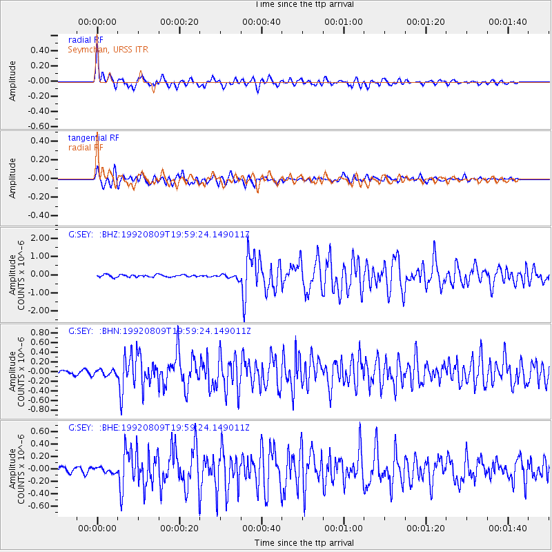
Signal To Noise
| Channel | StoN | STA | LTA |
| G:SEY: :BHN:19920809T19:59:24.149011Z | 1.0083327 | 5.8402495E-8 | 5.7919866E-8 |
| G:SEY: :BHE:19920809T19:59:24.149011Z | 0.784358 | 4.0966793E-8 | 5.2229712E-8 |
| G:SEY: :BHZ:19920809T19:59:24.149011Z | 2.0979352 | 1.3032749E-7 | 6.212179E-8 |
| Arrivals |
| Ps | 11 SECOND |
| PpPs | 28 SECOND |
| PsPs/PpSs | 39 SECOND |


