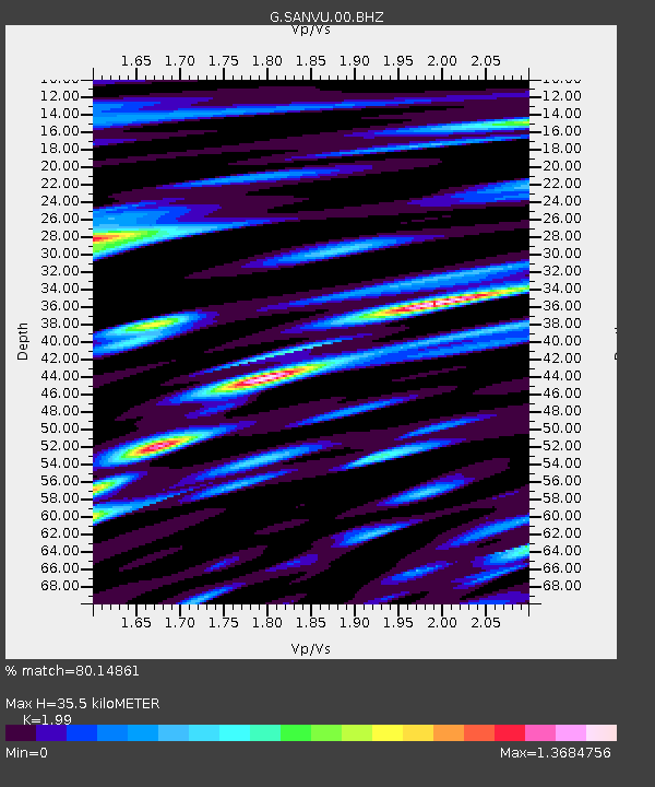
SANVU Espiritu Santo, Vanuatu - Earthquake Result Viewer

Earthquake location: Near East Coast Of Honshu, Japan
Earthquake latitude/longitude: 38.9/141.8
Earthquake time(UTC): 2012/06/17 (169) 20:32:20 GMT
Earthquake Depth: 36 km
Earthquake Magnitude: 6.0 MB, 5.9 MS, 6.3 MW, 6.4 MW
Earthquake Catalog/Contributor: WHDF/NEIC
Network: G GEOSCOPE
Station: SANVU Espiritu Santo, Vanuatu
Lat/Lon: 15.45 S/167.20 E
Elevation: 56 m
Distance: 59.1 deg
Az: 151.2 deg
Baz: 337.063 deg
Ray Param: 0.06237005
Estimated Moho Depth: 35.5 km
Estimated Crust Vp/Vs: 1.99
Assumed Crust Vp: 4.802 km/s
Estimated Crust Vs: 2.413 km/s
Estimated Crust Poisson's Ratio: 0.33
Radial Match: 80.14861 %
Radial Bump: 400
Transverse Match: 71.29686 %
Transverse Bump: 400
SOD ConfigId: 460165
Insert Time: 2013-02-11 20:58:59.309 +0000
GWidth: 2.5
Max Bumps: 400
Tol: 0.001

Signal To Noise

ChannelStoNSTALTA
G:SANVU:00:BHZ:20120617T20:41:46.399998Z2.70576458.755931E-73.2360285E-7
G:SANVU:00:BHN:20120617T20:41:46.399998Z1.35551634.6539927E-73.4333726E-7
G:SANVU:00:BHE:20120617T20:41:46.399998Z1.0063943.6569412E-73.6337073E-7
Arrivals
Ps7.5 SECOND
PpPs22 SECOND
PsPs/PpSs29 SECOND