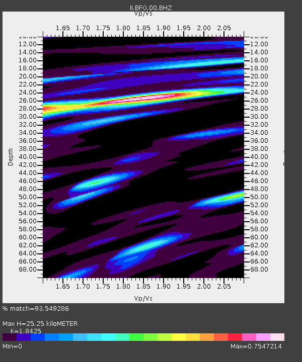
BFO Black Forest Observatory, Schiltach, Germany - Earthquake Result Viewer
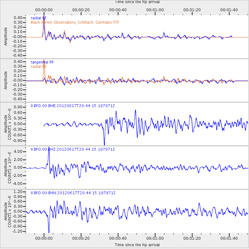
Earthquake location: Near East Coast Of Honshu, Japan
Earthquake latitude/longitude: 38.9/141.8
Earthquake time(UTC): 2012/06/17 (169) 20:32:20 GMT
Earthquake Depth: 36 km
Earthquake Magnitude: 6.0 MB, 5.9 MS, 6.3 MW, 6.4 MW
Earthquake Catalog/Contributor: WHDF/NEIC
Network: II Global Seismograph Network (GSN - IRIS/IDA)
Station: BFO Black Forest Observatory, Schiltach, Germany
Lat/Lon: 48.33 N/8.33 E
Elevation: 589 m
Distance: 83.8 deg
Az: 330.865 deg
Baz: 34.692 deg
Ray Param: 0.045865666
Estimated Moho Depth: 25.25 km
Estimated Crust Vp/Vs: 1.84
Assumed Crust Vp: 6.264 km/s
Estimated Crust Vs: 3.4 km/s
Estimated Crust Poisson's Ratio: 0.29
Radial Match: 93.549286 %
Radial Bump: 349
Transverse Match: 86.38091 %
Transverse Bump: 400
SOD ConfigId: 460165
Insert Time: 2013-02-11 20:59:44.503 +0000
GWidth: 2.5
Max Bumps: 400
Tol: 0.001

Signal To Noise

ChannelStoNSTALTA
II:BFO:00:BHZ:20120617T20:44:15.197971Z36.3758961.6532687E-64.5449568E-8
II:BFO:00:BHN:20120617T20:44:15.197971Z5.9282734.1957517E-77.077528E-8
II:BFO:00:BHE:20120617T20:44:15.197971Z6.31716633.5741704E-75.6578696E-8
Arrivals
Ps3.5 SECOND
PpPs11 SECOND
PsPs/PpSs15 SECOND