You are here: Home > Network List > IW - Intermountain West Stations List
> Station FXWY Fox Creek, Wyoming, USA > Earthquake Result Viewer
FXWY Fox Creek, Wyoming, USA - Earthquake Result Viewer
| Earthquake location: |
Near East Coast Of Honshu, Japan |
| Earthquake latitude/longitude: |
38.9/141.8 |
| Earthquake time(UTC): |
2012/06/17 (169) 20:32:20 GMT |
| Earthquake Depth: |
36 km |
| Earthquake Magnitude: |
6.0 MB, 5.9 MS, 6.3 MW, 6.4 MW |
| Earthquake Catalog/Contributor: |
WHDF/NEIC |
|
| Network: |
IW Intermountain West |
| Station: |
FXWY Fox Creek, Wyoming, USA |
| Lat/Lon: |
43.64 N/111.03 W |
| Elevation: |
2254 m |
|
| Distance: |
74.7 deg |
| Az: |
45.984 deg |
| Baz: |
309.402 deg |
| Ray Param: |
0.052080188 |
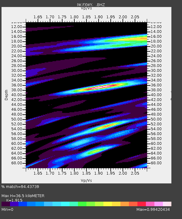
| Estimated Moho Depth: |
36.5 km |
| Estimated Crust Vp/Vs: |
1.91 |
| Assumed Crust Vp: |
6.207 km/s |
| Estimated Crust Vs: |
3.241 km/s |
| Estimated Crust Poisson's Ratio: |
0.31 |
|
| Radial Match: |
94.43739 % |
| Radial Bump: |
400 |
| Transverse Match: |
82.00694 % |
| Transverse Bump: |
400 |
| SOD ConfigId: |
460165 |
| Insert Time: |
2013-02-11 21:01:32.922 +0000 |
| GWidth: |
2.5 |
| Max Bumps: |
400 |
| Tol: |
0.001 |
|

Signal To Noise
| Channel | StoN | STA | LTA |
| IW:FXWY: :BHZ:20120617T20:43:25.795017Z | 6.764745 | 3.9514987E-7 | 5.8413118E-8 |
| IW:FXWY: :BHN:20120617T20:43:25.795017Z | 3.1684089 | 1.2249076E-7 | 3.8660023E-8 |
| IW:FXWY: :BHE:20120617T20:43:25.795017Z | 2.775007 | 1.3968796E-7 | 5.0337878E-8 |
| Arrivals |
| Ps | 5.5 SECOND |
| PpPs | 17 SECOND |
| PsPs/PpSs | 22 SECOND |


