You are here: Home > Network List > TA - USArray Transportable Network (new EarthScope stations) Stations List
> Station R56A Bull Pasture Mountain, McDowell, VA, USA > Earthquake Result Viewer
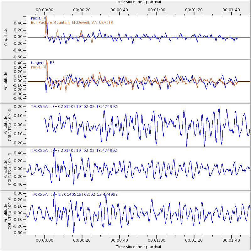
R56A Bull Pasture Mountain, McDowell, VA, USA - Earthquake Result Viewer
*The percent match for this event was below the threshold and hence no stack was calculated.
| Earthquake location: |
Central East Pacific Rise |
| Earthquake latitude/longitude: |
-4.8/-105.5 |
| Earthquake time(UTC): |
2014/05/19 (139) 01:53:54 GMT |
| Earthquake Depth: |
10 km |
| Earthquake Magnitude: |
5.5 MWB, 5.6 MWC |
| Earthquake Catalog/Contributor: |
NEIC PDE/NEIC COMCAT |
|
| Network: |
TA USArray Transportable Network (new EarthScope stations) |
| Station: |
R56A Bull Pasture Mountain, McDowell, VA, USA |
| Lat/Lon: |
38.41 N/79.40 W |
| Elevation: |
902 m |
|
| Distance: |
49.3 deg |
| Az: |
27.157 deg |
| Baz: |
215.379 deg |
| Ray Param: |
$rayparam |
*The percent match for this event was below the threshold and hence was not used in the summary stack. |
|
| Radial Match: |
72.71295 % |
| Radial Bump: |
400 |
| Transverse Match: |
54.259438 % |
| Transverse Bump: |
400 |
| SOD ConfigId: |
3390531 |
| Insert Time: |
2019-04-11 23:17:25.282 +0000 |
| GWidth: |
2.5 |
| Max Bumps: |
400 |
| Tol: |
0.001 |
|
Signal To Noise
| Channel | StoN | STA | LTA |
| TA:R56A: :BHZ:20140519T02:02:13.47499Z | 1.9460621 | 1.4865591E-7 | 7.638806E-8 |
| TA:R56A: :BHN:20140519T02:02:13.47499Z | 0.75612617 | 6.519339E-8 | 8.622026E-8 |
| TA:R56A: :BHE:20140519T02:02:13.47499Z | 1.646131 | 1.054128E-7 | 6.4036705E-8 |
| Arrivals |
| Ps | |
| PpPs | |
| PsPs/PpSs | |


