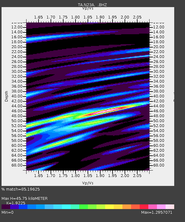
N23A Red Feather Lakes, CO, USA - Earthquake Result Viewer
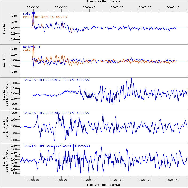
Earthquake location: Near East Coast Of Honshu, Japan
Earthquake latitude/longitude: 38.9/141.8
Earthquake time(UTC): 2012/06/17 (169) 20:32:20 GMT
Earthquake Depth: 36 km
Earthquake Magnitude: 6.0 MB, 5.9 MS, 6.3 MW, 6.4 MW
Earthquake Catalog/Contributor: WHDF/NEIC
Network: TA USArray Transportable Network (new EarthScope stations)
Station: N23A Red Feather Lakes, CO, USA
Lat/Lon: 40.89 N/105.94 W
Elevation: 2458 m
Distance: 79.4 deg
Az: 45.561 deg
Baz: 312.716 deg
Ray Param: 0.04895032
Estimated Moho Depth: 45.75 km
Estimated Crust Vp/Vs: 1.92
Assumed Crust Vp: 6.306 km/s
Estimated Crust Vs: 3.28 km/s
Estimated Crust Poisson's Ratio: 0.31
Radial Match: 85.19625 %
Radial Bump: 400
Transverse Match: 69.914764 %
Transverse Bump: 400
SOD ConfigId: 460165
Insert Time: 2013-02-11 21:08:43.602 +0000
GWidth: 2.5
Max Bumps: 400
Tol: 0.001

Signal To Noise

ChannelStoNSTALTA
TA:N23A: :BHZ:20120617T20:43:51.800022Z8.7742846.332765E-77.217415E-8
TA:N23A: :BHN:20120617T20:43:51.800022Z1.89232951.6945384E-78.954775E-8
TA:N23A: :BHE:20120617T20:43:51.800022Z2.3709123.111347E-71.3122995E-7
Arrivals
Ps6.9 SECOND
PpPs21 SECOND
PsPs/PpSs28 SECOND