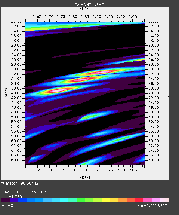
MDND Maddock, ND, USA - Earthquake Result Viewer
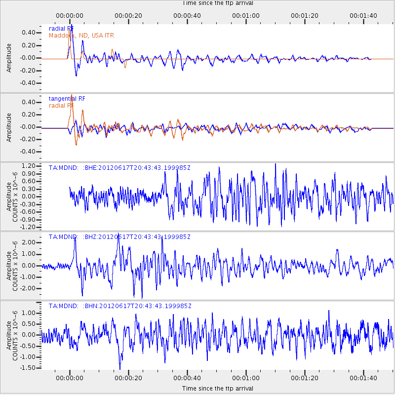
Earthquake location: Near East Coast Of Honshu, Japan
Earthquake latitude/longitude: 38.9/141.8
Earthquake time(UTC): 2012/06/17 (169) 20:32:20 GMT
Earthquake Depth: 36 km
Earthquake Magnitude: 6.0 MB, 5.9 MS, 6.3 MW, 6.4 MW
Earthquake Catalog/Contributor: WHDF/NEIC
Network: TA USArray Transportable Network (new EarthScope stations)
Station: MDND Maddock, ND, USA
Lat/Lon: 47.85 N/99.60 W
Elevation: 479 m
Distance: 77.8 deg
Az: 37.245 deg
Baz: 315.498 deg
Ray Param: 0.05001732
Estimated Moho Depth: 38.75 km
Estimated Crust Vp/Vs: 1.74
Assumed Crust Vp: 6.53 km/s
Estimated Crust Vs: 3.764 km/s
Estimated Crust Poisson's Ratio: 0.25
Radial Match: 90.58442 %
Radial Bump: 400
Transverse Match: 66.26607 %
Transverse Bump: 400
SOD ConfigId: 460165
Insert Time: 2013-02-11 21:08:55.521 +0000
GWidth: 2.5
Max Bumps: 400
Tol: 0.001

Signal To Noise

ChannelStoNSTALTA
TA:MDND: :BHZ:20120617T20:43:43.199985Z7.3092781.076011E-61.4721168E-7
TA:MDND: :BHN:20120617T20:43:43.199985Z1.47975063.6716241E-72.4812454E-7
TA:MDND: :BHE:20120617T20:43:43.199985Z1.78381314.05823E-72.2750308E-7
Arrivals
Ps4.5 SECOND
PpPs16 SECOND
PsPs/PpSs20 SECOND