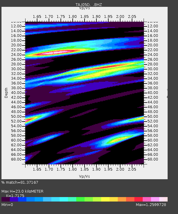
J05D Fort Rock, OR, USA - Earthquake Result Viewer
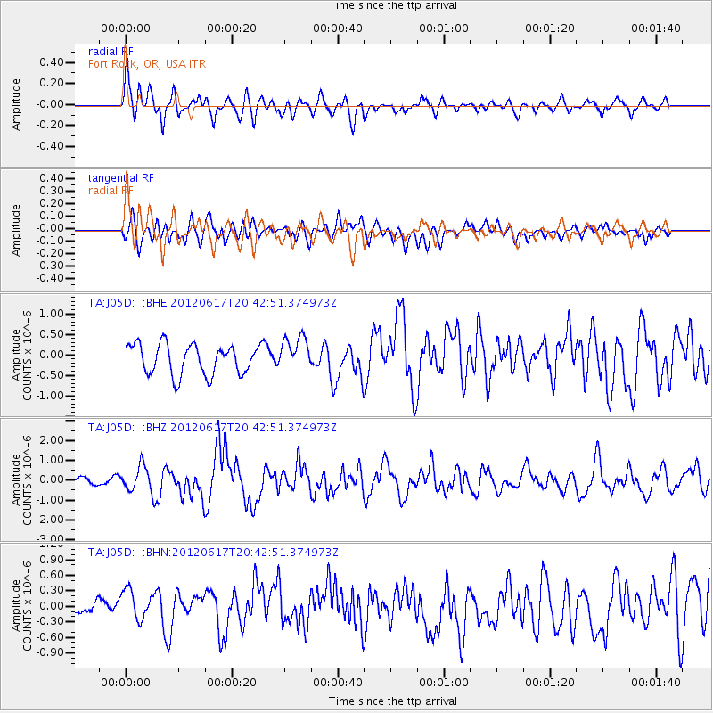
Earthquake location: Near East Coast Of Honshu, Japan
Earthquake latitude/longitude: 38.9/141.8
Earthquake time(UTC): 2012/06/17 (169) 20:32:20 GMT
Earthquake Depth: 36 km
Earthquake Magnitude: 6.0 MB, 5.9 MS, 6.3 MW, 6.4 MW
Earthquake Catalog/Contributor: WHDF/NEIC
Network: TA USArray Transportable Network (new EarthScope stations)
Station: J05D Fort Rock, OR, USA
Lat/Lon: 43.28 N/121.23 W
Elevation: 1541 m
Distance: 69.0 deg
Az: 50.948 deg
Baz: 303.944 deg
Ray Param: 0.055890165
Estimated Moho Depth: 23.0 km
Estimated Crust Vp/Vs: 1.72
Assumed Crust Vp: 6.597 km/s
Estimated Crust Vs: 3.841 km/s
Estimated Crust Poisson's Ratio: 0.24
Radial Match: 81.37167 %
Radial Bump: 400
Transverse Match: 60.878616 %
Transverse Bump: 400
SOD ConfigId: 460165
Insert Time: 2013-02-11 21:09:45.286 +0000
GWidth: 2.5
Max Bumps: 400
Tol: 0.001

Signal To Noise

ChannelStoNSTALTA
TA:J05D: :BHZ:20120617T20:42:51.374973Z4.5933915.967106E-71.2990635E-7
TA:J05D: :BHN:20120617T20:42:51.374973Z1.68103813.0981792E-71.8430154E-7
TA:J05D: :BHE:20120617T20:42:51.374973Z1.17619494.2843038E-73.6425118E-7
Arrivals
Ps2.6 SECOND
PpPs9.1 SECOND
PsPs/PpSs12 SECOND