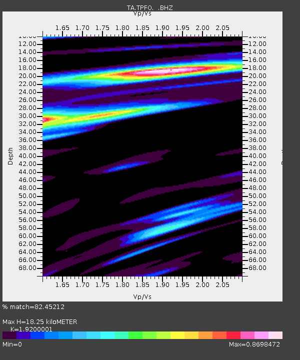
TPFO Pinon Flats, CA, USA - Earthquake Result Viewer
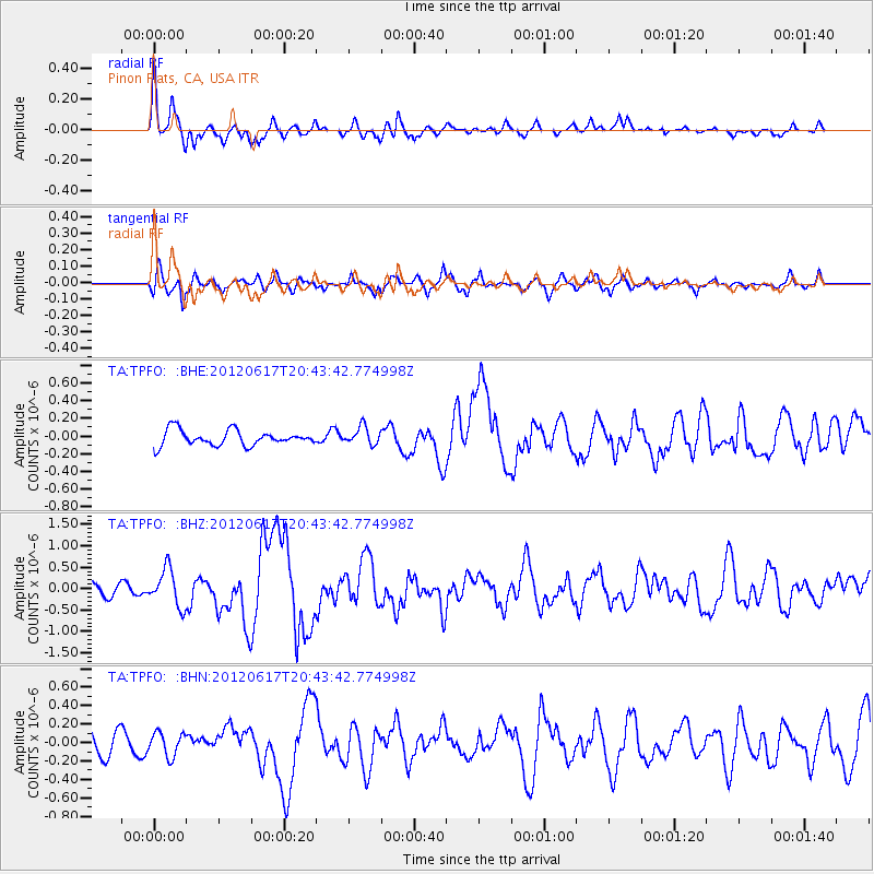
Earthquake location: Near East Coast Of Honshu, Japan
Earthquake latitude/longitude: 38.9/141.8
Earthquake time(UTC): 2012/06/17 (169) 20:32:20 GMT
Earthquake Depth: 36 km
Earthquake Magnitude: 6.0 MB, 5.9 MS, 6.3 MW, 6.4 MW
Earthquake Catalog/Contributor: WHDF/NEIC
Network: TA USArray Transportable Network (new EarthScope stations)
Station: TPFO Pinon Flats, CA, USA
Lat/Lon: 33.61 N/116.45 W
Elevation: 1275 m
Distance: 77.7 deg
Az: 56.75 deg
Baz: 308.584 deg
Ray Param: 0.05006945
Estimated Moho Depth: 18.25 km
Estimated Crust Vp/Vs: 1.92
Assumed Crust Vp: 6.264 km/s
Estimated Crust Vs: 3.262 km/s
Estimated Crust Poisson's Ratio: 0.31
Radial Match: 82.45212 %
Radial Bump: 400
Transverse Match: 83.13224 %
Transverse Bump: 400
SOD ConfigId: 460165
Insert Time: 2013-02-11 21:10:25.117 +0000
GWidth: 2.5
Max Bumps: 400
Tol: 0.001

Signal To Noise

ChannelStoNSTALTA
TA:TPFO: :BHZ:20120617T20:43:42.774998Z2.57414534.3561178E-71.692258E-7
TA:TPFO: :BHN:20120617T20:43:42.774998Z0.866507951.2756422E-71.4721645E-7
TA:TPFO: :BHE:20120617T20:43:42.774998Z1.16219141.0006671E-78.610175E-8
Arrivals
Ps2.8 SECOND
PpPs8.3 SECOND
PsPs/PpSs11 SECOND