D34A Park Rapids, MN, USA - Earthquake Result Viewer
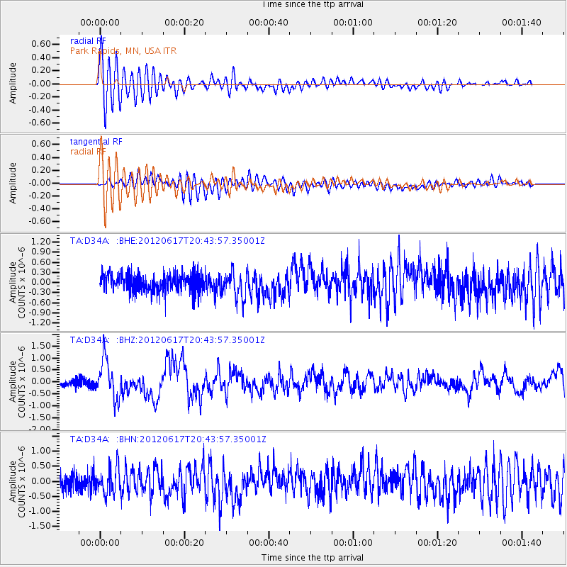
Earthquake location: Near East Coast Of Honshu, Japan
Earthquake latitude/longitude: 38.9/141.8
Earthquake time(UTC): 2012/06/17 (169) 20:32:20 GMT
Earthquake Depth: 36 km
Earthquake Magnitude: 6.0 MB, 5.9 MS, 6.3 MW, 6.4 MW
Earthquake Catalog/Contributor: WHDF/NEIC
Network: TA USArray Transportable Network (new EarthScope stations)
Station: D34A Park Rapids, MN, USA
Lat/Lon: 47.09 N/95.20 W
Elevation: 476 m
Distance: 80.4 deg
Az: 35.55 deg
Baz: 318.416 deg
Ray Param: 0.048246335
Estimated Moho Depth: 24.25 km
Estimated Crust Vp/Vs: 2.03
Assumed Crust Vp: 6.419 km/s
Estimated Crust Vs: 3.162 km/s
Estimated Crust Poisson's Ratio: 0.34
Radial Match: 84.53261 %
Radial Bump: 400
Transverse Match: 73.724075 %
Transverse Bump: 400
SOD ConfigId: 460165
Insert Time: 2013-02-11 21:11:51.481 +0000
GWidth: 2.5
Max Bumps: 400
Tol: 0.001

Signal To Noise

ChannelStoNSTALTA
TA:D34A: :BHZ:20120617T20:43:57.35001Z6.80798538.2904353E-71.2177517E-7
TA:D34A: :BHN:20120617T20:43:57.35001Z2.02370174.373724E-72.1612493E-7
TA:D34A: :BHE:20120617T20:43:57.35001Z1.50095253.9777012E-72.650118E-7
Arrivals
Ps4.0 SECOND
PpPs11 SECOND
PsPs/PpSs15 SECOND