You are here: Home > Network List > TA - USArray Transportable Network (new EarthScope stations) Stations List
> Station C35A Jirik Farms, Max, MN, USA > Earthquake Result Viewer
C35A Jirik Farms, Max, MN, USA - Earthquake Result Viewer
| Earthquake location: |
Near East Coast Of Honshu, Japan |
| Earthquake latitude/longitude: |
38.9/141.8 |
| Earthquake time(UTC): |
2012/06/17 (169) 20:32:20 GMT |
| Earthquake Depth: |
36 km |
| Earthquake Magnitude: |
6.0 MB, 5.9 MS, 6.3 MW, 6.4 MW |
| Earthquake Catalog/Contributor: |
WHDF/NEIC |
|
| Network: |
TA USArray Transportable Network (new EarthScope stations) |
| Station: |
C35A Jirik Farms, Max, MN, USA |
| Lat/Lon: |
47.70 N/93.98 W |
| Elevation: |
426 m |
|
| Distance: |
80.5 deg |
| Az: |
34.507 deg |
| Baz: |
319.137 deg |
| Ray Param: |
0.048190102 |
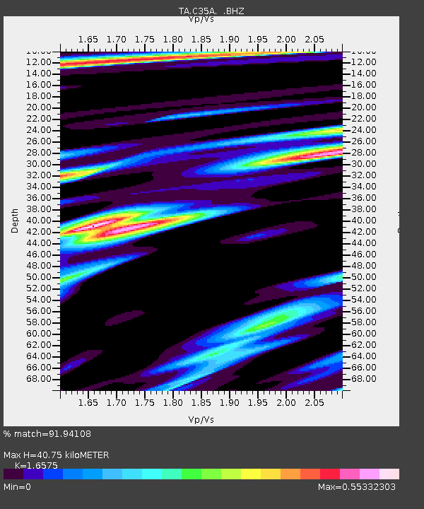
| Estimated Moho Depth: |
40.75 km |
| Estimated Crust Vp/Vs: |
1.66 |
| Assumed Crust Vp: |
6.571 km/s |
| Estimated Crust Vs: |
3.964 km/s |
| Estimated Crust Poisson's Ratio: |
0.21 |
|
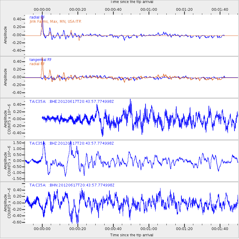
| Radial Match: |
91.94108 % |
| Radial Bump: |
400 |
| Transverse Match: |
67.23892 % |
| Transverse Bump: |
400 |
| SOD ConfigId: |
460165 |
| Insert Time: |
2013-02-11 21:13:06.398 +0000 |
| GWidth: |
2.5 |
| Max Bumps: |
400 |
| Tol: |
0.001 |
|
Signal To Noise
| Channel | StoN | STA | LTA |
| TA:C35A: :BHZ:20120617T20:43:57.774998Z | 10.004469 | 7.817257E-7 | 7.8137646E-8 |
| TA:C35A: :BHN:20120617T20:43:57.774998Z | 2.7003696 | 2.0636506E-7 | 7.6421045E-8 |
| TA:C35A: :BHE:20120617T20:43:57.774998Z | 3.794411 | 2.2019287E-7 | 5.8030846E-8 |
| Arrivals |
| Ps | 4.2 SECOND |
| PpPs | 16 SECOND |
| PsPs/PpSs | 20 SECOND |


