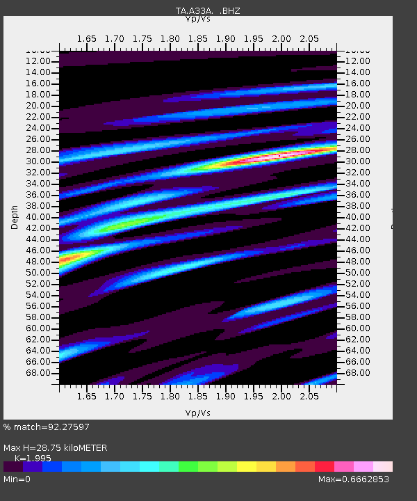
A33A Warroad, MN, USA - Earthquake Result Viewer
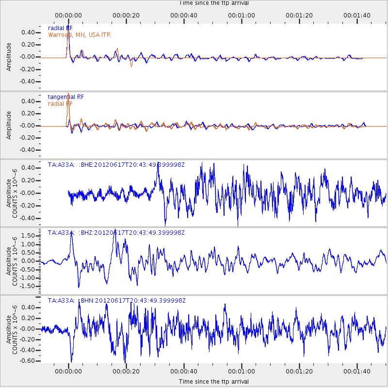
Earthquake location: Near East Coast Of Honshu, Japan
Earthquake latitude/longitude: 38.9/141.8
Earthquake time(UTC): 2012/06/17 (169) 20:32:20 GMT
Earthquake Depth: 36 km
Earthquake Magnitude: 6.0 MB, 5.9 MS, 6.3 MW, 6.4 MW
Earthquake Catalog/Contributor: WHDF/NEIC
Network: TA USArray Transportable Network (new EarthScope stations)
Station: A33A Warroad, MN, USA
Lat/Lon: 48.94 N/95.39 W
Elevation: 329 m
Distance: 78.9 deg
Az: 34.395 deg
Baz: 318.064 deg
Ray Param: 0.04925142
Estimated Moho Depth: 28.75 km
Estimated Crust Vp/Vs: 2.00
Assumed Crust Vp: 6.419 km/s
Estimated Crust Vs: 3.218 km/s
Estimated Crust Poisson's Ratio: 0.33
Radial Match: 92.27597 %
Radial Bump: 306
Transverse Match: 77.338844 %
Transverse Bump: 400
SOD ConfigId: 460165
Insert Time: 2013-02-11 21:14:04.851 +0000
GWidth: 2.5
Max Bumps: 400
Tol: 0.001

Signal To Noise

ChannelStoNSTALTA
TA:A33A: :BHZ:20120617T20:43:49.399998Z13.6686828.0306586E-75.875225E-8
TA:A33A: :BHN:20120617T20:43:49.399998Z5.12088442.7353337E-75.341526E-8
TA:A33A: :BHE:20120617T20:43:49.399998Z4.2753162.346295E-75.4880033E-8
Arrivals
Ps4.6 SECOND
PpPs13 SECOND
PsPs/PpSs18 SECOND