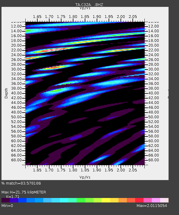
C32A Crookston, MN, USA - Earthquake Result Viewer

Earthquake location: Near East Coast Of Honshu, Japan
Earthquake latitude/longitude: 38.9/141.8
Earthquake time(UTC): 2012/06/17 (169) 20:32:20 GMT
Earthquake Depth: 36 km
Earthquake Magnitude: 6.0 MB, 5.9 MS, 6.3 MW, 6.4 MW
Earthquake Catalog/Contributor: WHDF/NEIC
Network: TA USArray Transportable Network (new EarthScope stations)
Station: C32A Crookston, MN, USA
Lat/Lon: 47.83 N/96.53 W
Elevation: 286 m
Distance: 79.3 deg
Az: 35.728 deg
Baz: 317.469 deg
Ray Param: 0.049036663
Estimated Moho Depth: 21.75 km
Estimated Crust Vp/Vs: 1.71
Assumed Crust Vp: 6.498 km/s
Estimated Crust Vs: 3.8 km/s
Estimated Crust Poisson's Ratio: 0.24
Radial Match: 83.578186 %
Radial Bump: 400
Transverse Match: 59.158047 %
Transverse Bump: 400
SOD ConfigId: 460165
Insert Time: 2013-02-11 21:15:15.121 +0000
GWidth: 2.5
Max Bumps: 400
Tol: 0.001

Signal To Noise

ChannelStoNSTALTA
TA:C32A: :BHZ:20120617T20:43:51.124973Z5.97361957.783191E-71.3029272E-7
TA:C32A: :BHN:20120617T20:43:51.124973Z5.3386477.2217915E-71.3527382E-7
TA:C32A: :BHE:20120617T20:43:51.124973Z4.0244734.552457E-71.1311933E-7
Arrivals
Ps2.5 SECOND
PpPs8.8 SECOND
PsPs/PpSs11 SECOND