You are here: Home > Network List > TA - USArray Transportable Network (new EarthScope stations) Stations List
> Station O56A Blue Knob State Park, Imler, PA, USA > Earthquake Result Viewer
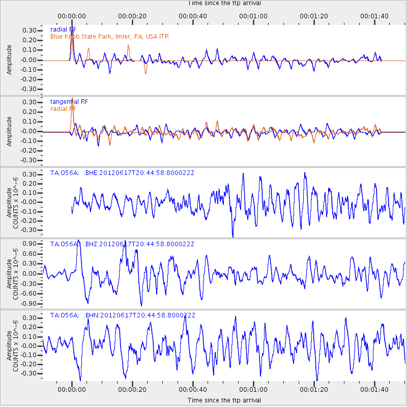
O56A Blue Knob State Park, Imler, PA, USA - Earthquake Result Viewer
*The percent match for this event was below the threshold and hence no stack was calculated.
| Earthquake location: |
Near East Coast Of Honshu, Japan |
| Earthquake latitude/longitude: |
38.9/141.8 |
| Earthquake time(UTC): |
2012/06/17 (169) 20:32:20 GMT |
| Earthquake Depth: |
36 km |
| Earthquake Magnitude: |
6.0 MB, 5.9 MS, 6.3 MW, 6.4 MW |
| Earthquake Catalog/Contributor: |
WHDF/NEIC |
|
| Network: |
TA USArray Transportable Network (new EarthScope stations) |
| Station: |
O56A Blue Knob State Park, Imler, PA, USA |
| Lat/Lon: |
40.27 N/78.57 W |
| Elevation: |
684 m |
|
| Distance: |
93.0 deg |
| Az: |
29.772 deg |
| Baz: |
329.586 deg |
| Ray Param: |
$rayparam |
*The percent match for this event was below the threshold and hence was not used in the summary stack. |
|
| Radial Match: |
78.24146 % |
| Radial Bump: |
400 |
| Transverse Match: |
64.95783 % |
| Transverse Bump: |
400 |
| SOD ConfigId: |
460165 |
| Insert Time: |
2013-02-11 21:15:41.032 +0000 |
| GWidth: |
2.5 |
| Max Bumps: |
400 |
| Tol: |
0.001 |
|
Signal To Noise
| Channel | StoN | STA | LTA |
| TA:O56A: :BHZ:20120617T20:44:58.800022Z | 4.5327163 | 5.1143985E-7 | 1.1283298E-7 |
| TA:O56A: :BHN:20120617T20:44:58.800022Z | 2.1008844 | 1.6968058E-7 | 8.0766256E-8 |
| TA:O56A: :BHE:20120617T20:44:58.800022Z | 0.94164747 | 6.174325E-8 | 6.556939E-8 |
| Arrivals |
| Ps | |
| PpPs | |
| PsPs/PpSs | |


