You are here: Home > Network List > TA - USArray Transportable Network (new EarthScope stations) Stations List
> Station N54A Moraine State Park, Portersville, PA, USA > Earthquake Result Viewer
N54A Moraine State Park, Portersville, PA, USA - Earthquake Result Viewer
| Earthquake location: |
Near East Coast Of Honshu, Japan |
| Earthquake latitude/longitude: |
38.9/141.8 |
| Earthquake time(UTC): |
2012/06/17 (169) 20:32:20 GMT |
| Earthquake Depth: |
36 km |
| Earthquake Magnitude: |
6.0 MB, 5.9 MS, 6.3 MW, 6.4 MW |
| Earthquake Catalog/Contributor: |
WHDF/NEIC |
|
| Network: |
TA USArray Transportable Network (new EarthScope stations) |
| Station: |
N54A Moraine State Park, Portersville, PA, USA |
| Lat/Lon: |
40.96 N/79.99 W |
| Elevation: |
408 m |
|
| Distance: |
91.8 deg |
| Az: |
30.347 deg |
| Baz: |
328.639 deg |
| Ray Param: |
0.041542783 |
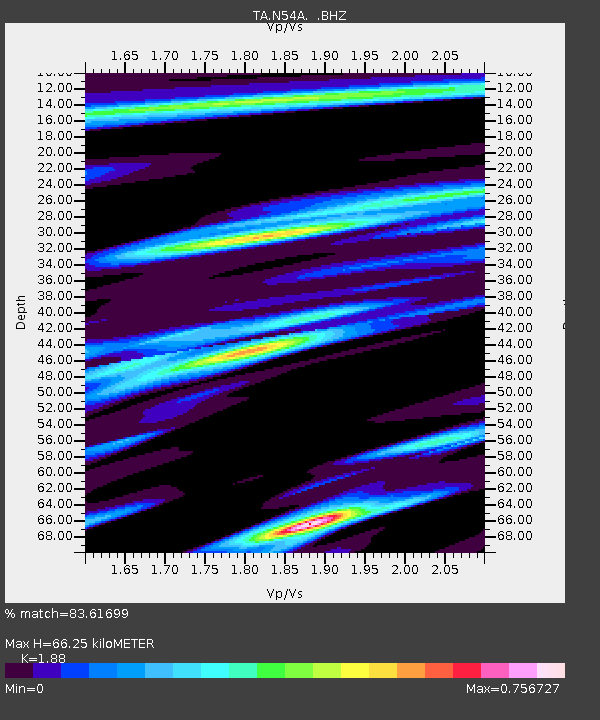
| Estimated Moho Depth: |
66.25 km |
| Estimated Crust Vp/Vs: |
1.88 |
| Assumed Crust Vp: |
6.121 km/s |
| Estimated Crust Vs: |
3.256 km/s |
| Estimated Crust Poisson's Ratio: |
0.30 |
|
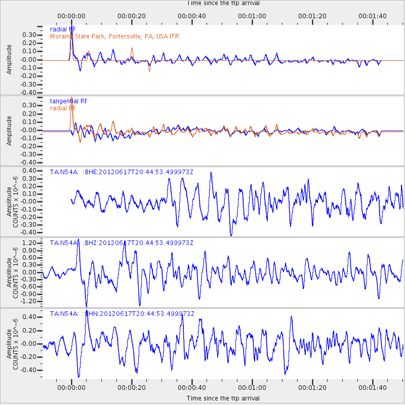
| Radial Match: |
83.61699 % |
| Radial Bump: |
400 |
| Transverse Match: |
65.4966 % |
| Transverse Bump: |
400 |
| SOD ConfigId: |
460165 |
| Insert Time: |
2013-02-11 21:15:53.320 +0000 |
| GWidth: |
2.5 |
| Max Bumps: |
400 |
| Tol: |
0.001 |
|
Signal To Noise
| Channel | StoN | STA | LTA |
| TA:N54A: :BHZ:20120617T20:44:53.499973Z | 4.607657 | 5.979544E-7 | 1.2977407E-7 |
| TA:N54A: :BHN:20120617T20:44:53.499973Z | 2.9846966 | 2.2579991E-7 | 7.565255E-8 |
| TA:N54A: :BHE:20120617T20:44:53.499973Z | 1.7805904 | 1.244847E-7 | 6.991203E-8 |
| Arrivals |
| Ps | 9.7 SECOND |
| PpPs | 31 SECOND |
| PsPs/PpSs | 40 SECOND |


