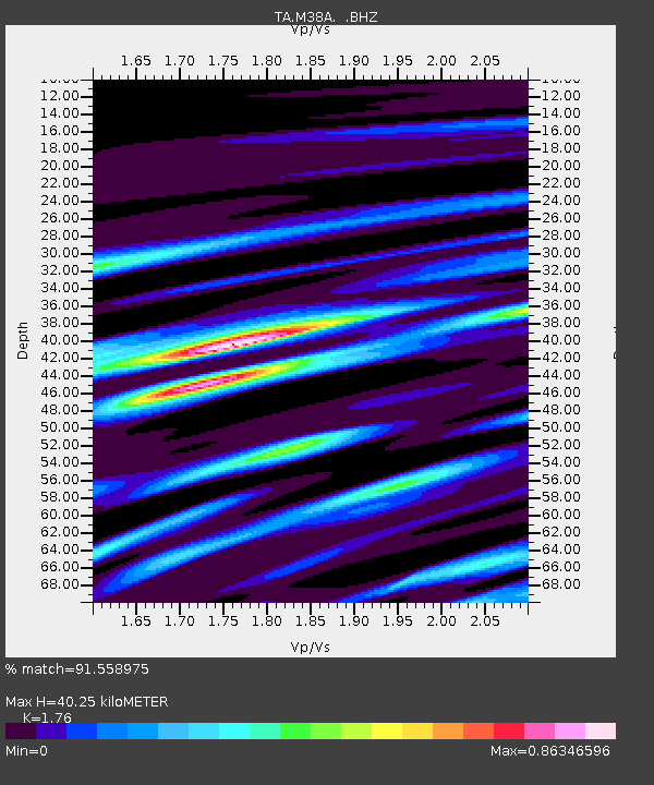
M38A Pleasantville, IA, USA - Earthquake Result Viewer

Earthquake location: Near East Coast Of Honshu, Japan
Earthquake latitude/longitude: 38.9/141.8
Earthquake time(UTC): 2012/06/17 (169) 20:32:20 GMT
Earthquake Depth: 36 km
Earthquake Magnitude: 6.0 MB, 5.9 MS, 6.3 MW, 6.4 MW
Earthquake Catalog/Contributor: WHDF/NEIC
Network: TA USArray Transportable Network (new EarthScope stations)
Station: M38A Pleasantville, IA, USA
Lat/Lon: 41.42 N/93.20 W
Elevation: 258 m
Distance: 85.6 deg
Az: 38.177 deg
Baz: 320.127 deg
Ray Param: 0.044570927
Estimated Moho Depth: 40.25 km
Estimated Crust Vp/Vs: 1.76
Assumed Crust Vp: 6.498 km/s
Estimated Crust Vs: 3.692 km/s
Estimated Crust Poisson's Ratio: 0.26
Radial Match: 91.558975 %
Radial Bump: 400
Transverse Match: 63.65858 %
Transverse Bump: 400
SOD ConfigId: 460165
Insert Time: 2013-02-11 21:16:27.600 +0000
GWidth: 2.5
Max Bumps: 400
Tol: 0.001

Signal To Noise

ChannelStoNSTALTA
TA:M38A: :BHZ:20120617T20:44:24.274998Z12.9731979.035523E-76.964762E-8
TA:M38A: :BHN:20120617T20:44:24.274998Z2.09927962.052576E-79.777526E-8
TA:M38A: :BHE:20120617T20:44:24.274998Z2.09941842.9313054E-71.3962463E-7
Arrivals
Ps4.8 SECOND
PpPs17 SECOND
PsPs/PpSs22 SECOND