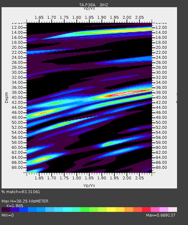
P38A Dawn, MO, USA - Earthquake Result Viewer
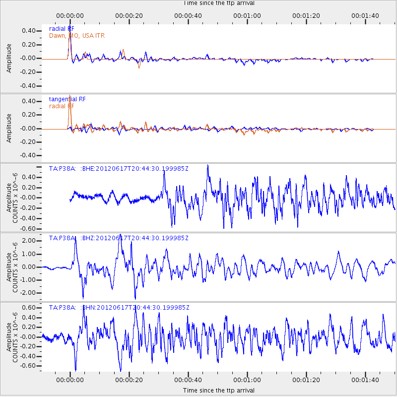
Earthquake location: Near East Coast Of Honshu, Japan
Earthquake latitude/longitude: 38.9/141.8
Earthquake time(UTC): 2012/06/17 (169) 20:32:20 GMT
Earthquake Depth: 36 km
Earthquake Magnitude: 6.0 MB, 5.9 MS, 6.3 MW, 6.4 MW
Earthquake Catalog/Contributor: WHDF/NEIC
Network: TA USArray Transportable Network (new EarthScope stations)
Station: P38A Dawn, MO, USA
Lat/Lon: 39.62 N/93.53 W
Elevation: 248 m
Distance: 86.8 deg
Az: 39.525 deg
Baz: 319.998 deg
Ray Param: 0.043703496
Estimated Moho Depth: 38.25 km
Estimated Crust Vp/Vs: 1.99
Assumed Crust Vp: 6.498 km/s
Estimated Crust Vs: 3.273 km/s
Estimated Crust Poisson's Ratio: 0.33
Radial Match: 93.31061 %
Radial Bump: 375
Transverse Match: 82.659515 %
Transverse Bump: 400
SOD ConfigId: 460165
Insert Time: 2013-02-11 21:17:03.566 +0000
GWidth: 2.5
Max Bumps: 400
Tol: 0.001

Signal To Noise

ChannelStoNSTALTA
TA:P38A: :BHZ:20120617T20:44:30.199985Z20.2889611.0267406E-65.0605877E-8
TA:P38A: :BHN:20120617T20:44:30.199985Z5.7131192.8390488E-74.96935E-8
TA:P38A: :BHE:20120617T20:44:30.199985Z3.70793372.1551207E-75.812188E-8
Arrivals
Ps5.9 SECOND
PpPs17 SECOND
PsPs/PpSs23 SECOND