You are here: Home > Network List > TA - USArray Transportable Network (new EarthScope stations) Stations List
> Station Q38A Cook's Store, Concordia, MO, USA > Earthquake Result Viewer
Q38A Cook's Store, Concordia, MO, USA - Earthquake Result Viewer
| Earthquake location: |
Near East Coast Of Honshu, Japan |
| Earthquake latitude/longitude: |
38.9/141.8 |
| Earthquake time(UTC): |
2012/06/17 (169) 20:32:20 GMT |
| Earthquake Depth: |
36 km |
| Earthquake Magnitude: |
6.0 MB, 5.9 MS, 6.3 MW, 6.4 MW |
| Earthquake Catalog/Contributor: |
WHDF/NEIC |
|
| Network: |
TA USArray Transportable Network (new EarthScope stations) |
| Station: |
Q38A Cook's Store, Concordia, MO, USA |
| Lat/Lon: |
38.96 N/93.62 W |
| Elevation: |
228 m |
|
| Distance: |
87.3 deg |
| Az: |
40.003 deg |
| Baz: |
319.968 deg |
| Ray Param: |
0.04336656 |
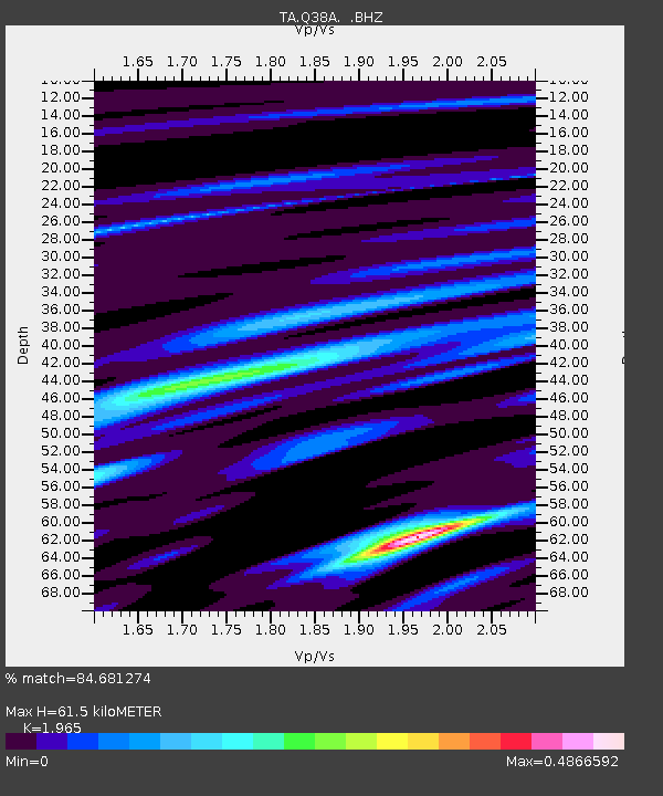
| Estimated Moho Depth: |
61.5 km |
| Estimated Crust Vp/Vs: |
1.97 |
| Assumed Crust Vp: |
6.498 km/s |
| Estimated Crust Vs: |
3.307 km/s |
| Estimated Crust Poisson's Ratio: |
0.33 |
|
| Radial Match: |
84.681274 % |
| Radial Bump: |
400 |
| Transverse Match: |
67.6005 % |
| Transverse Bump: |
400 |
| SOD ConfigId: |
460165 |
| Insert Time: |
2013-02-11 21:17:16.694 +0000 |
| GWidth: |
2.5 |
| Max Bumps: |
400 |
| Tol: |
0.001 |
|

Signal To Noise
| Channel | StoN | STA | LTA |
| TA:Q38A: :BHZ:20120617T20:44:32.449985Z | 17.87118 | 7.887553E-7 | 4.4135604E-8 |
| TA:Q38A: :BHN:20120617T20:44:32.449985Z | 4.6341777 | 2.8403676E-7 | 6.129172E-8 |
| TA:Q38A: :BHE:20120617T20:44:32.449985Z | 3.7361054 | 2.0670639E-7 | 5.53267E-8 |
| Arrivals |
| Ps | 9.3 SECOND |
| PpPs | 27 SECOND |
| PsPs/PpSs | 37 SECOND |


