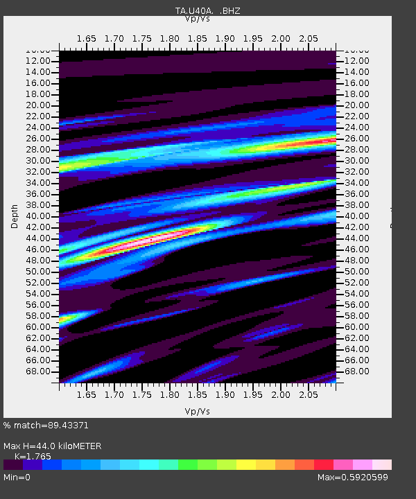
U40A Yellville, AR, USA - Earthquake Result Viewer
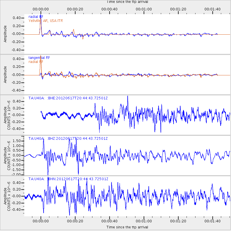
Earthquake location: Near East Coast Of Honshu, Japan
Earthquake latitude/longitude: 38.9/141.8
Earthquake time(UTC): 2012/06/17 (169) 20:32:20 GMT
Earthquake Depth: 36 km
Earthquake Magnitude: 6.0 MB, 5.9 MS, 6.3 MW, 6.4 MW
Earthquake Catalog/Contributor: WHDF/NEIC
Network: TA USArray Transportable Network (new EarthScope stations)
Station: U40A Yellville, AR, USA
Lat/Lon: 36.36 N/92.85 W
Elevation: 374 m
Distance: 89.7 deg
Az: 41.201 deg
Baz: 320.465 deg
Ray Param: 0.041721504
Estimated Moho Depth: 44.0 km
Estimated Crust Vp/Vs: 1.76
Assumed Crust Vp: 6.53 km/s
Estimated Crust Vs: 3.7 km/s
Estimated Crust Poisson's Ratio: 0.26
Radial Match: 89.43371 %
Radial Bump: 400
Transverse Match: 67.71106 %
Transverse Bump: 400
SOD ConfigId: 460165
Insert Time: 2013-02-11 21:18:42.956 +0000
GWidth: 2.5
Max Bumps: 400
Tol: 0.001

Signal To Noise

ChannelStoNSTALTA
TA:U40A: :BHZ:20120617T20:44:43.72501Z10.5048357.1132644E-76.771419E-8
TA:U40A: :BHN:20120617T20:44:43.72501Z3.5486372.1224054E-75.980903E-8
TA:U40A: :BHE:20120617T20:44:43.72501Z2.68874741.541219E-75.732108E-8
Arrivals
Ps5.3 SECOND
PpPs18 SECOND
PsPs/PpSs23 SECOND