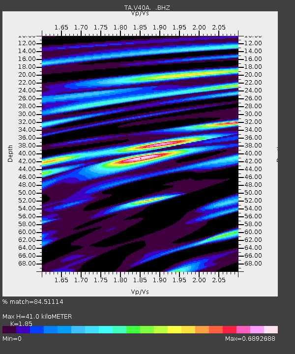
V40A Witts Springs, AR, USA - Earthquake Result Viewer

Earthquake location: Near East Coast Of Honshu, Japan
Earthquake latitude/longitude: 38.9/141.8
Earthquake time(UTC): 2012/06/17 (169) 20:32:20 GMT
Earthquake Depth: 36 km
Earthquake Magnitude: 6.0 MB, 5.9 MS, 6.3 MW, 6.4 MW
Earthquake Catalog/Contributor: WHDF/NEIC
Network: TA USArray Transportable Network (new EarthScope stations)
Station: V40A Witts Springs, AR, USA
Lat/Lon: 35.80 N/92.82 W
Elevation: 570 m
Distance: 90.1 deg
Az: 41.533 deg
Baz: 320.483 deg
Ray Param: 0.041690093
Estimated Moho Depth: 41.0 km
Estimated Crust Vp/Vs: 1.85
Assumed Crust Vp: 6.498 km/s
Estimated Crust Vs: 3.512 km/s
Estimated Crust Poisson's Ratio: 0.29
Radial Match: 84.51114 %
Radial Bump: 400
Transverse Match: 54.55073 %
Transverse Bump: 400
SOD ConfigId: 460165
Insert Time: 2013-02-11 21:19:56.028 +0000
GWidth: 2.5
Max Bumps: 400
Tol: 0.001

Signal To Noise

ChannelStoNSTALTA
TA:V40A: :BHZ:20120617T20:44:45.749973Z10.1697984.941184E-74.858685E-8
TA:V40A: :BHN:20120617T20:44:45.749973Z1.37827969.925051E-87.201044E-8
TA:V40A: :BHE:20120617T20:44:45.749973Z1.80744799.210011E-85.0955887E-8
Arrivals
Ps5.5 SECOND
PpPs18 SECOND
PsPs/PpSs23 SECOND