You are here: Home > Network List > TA - USArray Transportable Network (new EarthScope stations) Stations List
> Station 147A Livingston, AL, USA > Earthquake Result Viewer
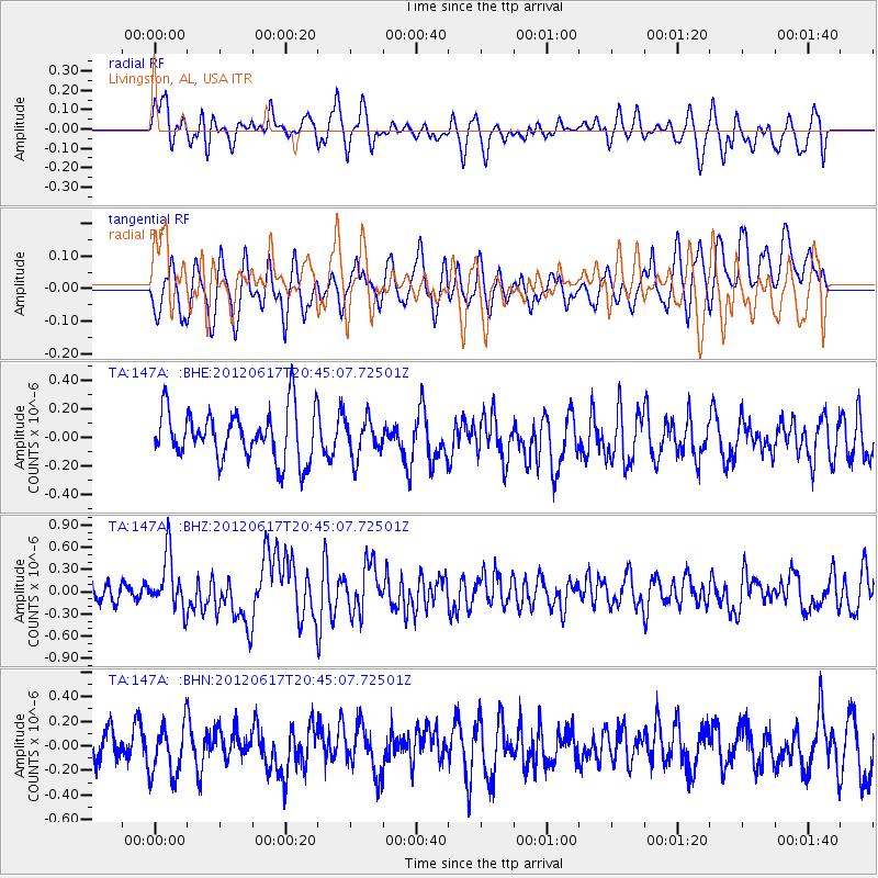
147A Livingston, AL, USA - Earthquake Result Viewer
*The percent match for this event was below the threshold and hence no stack was calculated.
| Earthquake location: |
Near East Coast Of Honshu, Japan |
| Earthquake latitude/longitude: |
38.9/141.8 |
| Earthquake time(UTC): |
2012/06/17 (169) 20:32:20 GMT |
| Earthquake Depth: |
36 km |
| Earthquake Magnitude: |
6.0 MB, 5.9 MS, 6.3 MW, 6.4 MW |
| Earthquake Catalog/Contributor: |
WHDF/NEIC |
|
| Network: |
TA USArray Transportable Network (new EarthScope stations) |
| Station: |
147A Livingston, AL, USA |
| Lat/Lon: |
32.67 N/88.27 W |
| Elevation: |
57 m |
|
| Distance: |
94.9 deg |
| Az: |
40.499 deg |
| Baz: |
323.08 deg |
| Ray Param: |
$rayparam |
*The percent match for this event was below the threshold and hence was not used in the summary stack. |
|
| Radial Match: |
56.352833 % |
| Radial Bump: |
400 |
| Transverse Match: |
64.25585 % |
| Transverse Bump: |
400 |
| SOD ConfigId: |
460165 |
| Insert Time: |
2013-02-11 21:21:13.460 +0000 |
| GWidth: |
2.5 |
| Max Bumps: |
400 |
| Tol: |
0.001 |
|
Signal To Noise
| Channel | StoN | STA | LTA |
| TA:147A: :BHZ:20120617T20:45:07.72501Z | 3.6128397 | 3.520614E-7 | 9.744728E-8 |
| TA:147A: :BHN:20120617T20:45:07.72501Z | 1.1599642 | 2.079022E-7 | 1.7923156E-7 |
| TA:147A: :BHE:20120617T20:45:07.72501Z | 0.76397383 | 1.3481429E-7 | 1.7646454E-7 |
| Arrivals |
| Ps | |
| PpPs | |
| PsPs/PpSs | |


