You are here: Home > Network List > TA - USArray Transportable Network (new EarthScope stations) Stations List
> Station Y43A Makayla and Karen, Gunnison, MS, USA > Earthquake Result Viewer
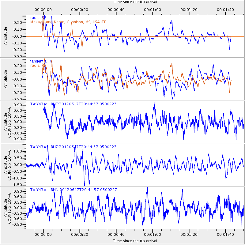
Y43A Makayla and Karen, Gunnison, MS, USA - Earthquake Result Viewer
*The percent match for this event was below the threshold and hence no stack was calculated.
| Earthquake location: |
Near East Coast Of Honshu, Japan |
| Earthquake latitude/longitude: |
38.9/141.8 |
| Earthquake time(UTC): |
2012/06/17 (169) 20:32:20 GMT |
| Earthquake Depth: |
36 km |
| Earthquake Magnitude: |
6.0 MB, 5.9 MS, 6.3 MW, 6.4 MW |
| Earthquake Catalog/Contributor: |
WHDF/NEIC |
|
| Network: |
TA USArray Transportable Network (new EarthScope stations) |
| Station: |
Y43A Makayla and Karen, Gunnison, MS, USA |
| Lat/Lon: |
33.91 N/90.93 W |
| Elevation: |
46 m |
|
| Distance: |
92.6 deg |
| Az: |
41.509 deg |
| Baz: |
321.562 deg |
| Ray Param: |
$rayparam |
*The percent match for this event was below the threshold and hence was not used in the summary stack. |
|
| Radial Match: |
60.20144 % |
| Radial Bump: |
400 |
| Transverse Match: |
53.45599 % |
| Transverse Bump: |
400 |
| SOD ConfigId: |
460165 |
| Insert Time: |
2013-02-11 21:21:25.028 +0000 |
| GWidth: |
2.5 |
| Max Bumps: |
400 |
| Tol: |
0.001 |
|
Signal To Noise
| Channel | StoN | STA | LTA |
| TA:Y43A: :BHZ:20120617T20:44:57.050022Z | 4.459037 | 4.975528E-7 | 1.1158301E-7 |
| TA:Y43A: :BHN:20120617T20:44:57.050022Z | 0.78542084 | 2.551192E-7 | 3.2481847E-7 |
| TA:Y43A: :BHE:20120617T20:44:57.050022Z | 0.33236915 | 1.3486816E-7 | 4.0577822E-7 |
| Arrivals |
| Ps | |
| PpPs | |
| PsPs/PpSs | |


