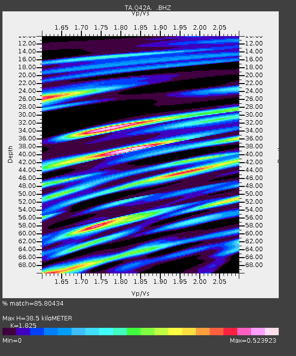
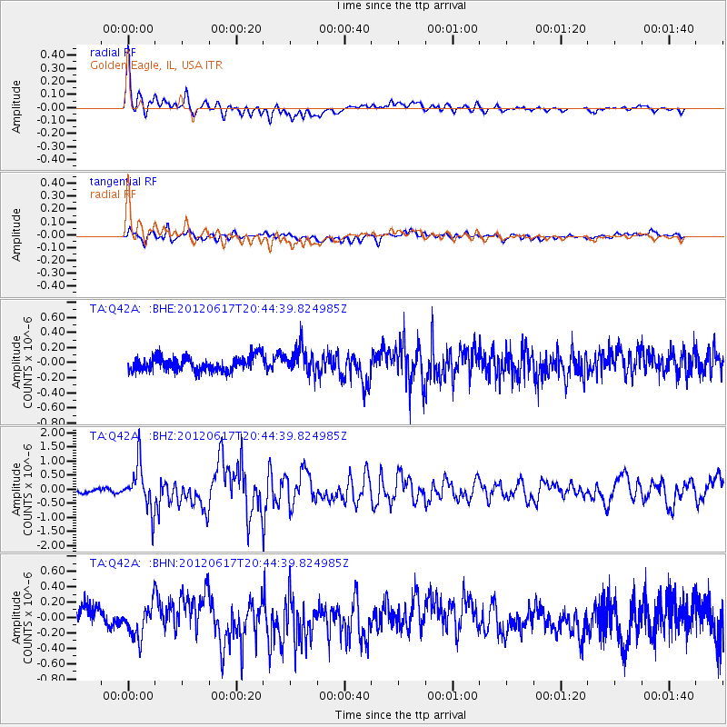
Q42A Golden Eagle, IL, USA - Earthquake Result Viewer

Earthquake location: Near East Coast Of Honshu, Japan
Earthquake latitude/longitude: 38.9/141.8
Earthquake time(UTC): 2012/06/17 (169) 20:32:20 GMT
Earthquake Depth: 36 km
Earthquake Magnitude: 6.0 MB, 5.9 MS, 6.3 MW, 6.4 MW
Earthquake Catalog/Contributor: WHDF/NEIC
Network: TA USArray Transportable Network (new EarthScope stations)
Station: Q42A Golden Eagle, IL, USA
Lat/Lon: 38.91 N/90.53 W
Elevation: 175 m
Distance: 88.9 deg
Az: 38.166 deg
Baz: 321.838 deg
Ray Param: 0.042218428
Estimated Moho Depth: 38.5 km
Estimated Crust Vp/Vs: 1.83
Assumed Crust Vp: 6.498 km/s
Estimated Crust Vs: 3.56 km/s
Estimated Crust Poisson's Ratio: 0.29
Radial Match: 85.80434 %
Radial Bump: 400
Transverse Match: 59.19104 %
Transverse Bump: 400
SOD ConfigId: 460165
Insert Time: 2013-02-11 21:22:25.180 +0000
GWidth: 2.5
Max Bumps: 400
Tol: 0.001

Signal To Noise

ChannelStoNSTALTA
TA:Q42A: :BHZ:20120617T20:44:39.824985Z8.9310148.0461126E-79.009181E-8
TA:Q42A: :BHN:20120617T20:44:39.824985Z1.65114012.1702282E-71.3143816E-7
TA:Q42A: :BHE:20120617T20:44:39.824985Z1.9070831.7908658E-79.3906024E-8
Arrivals
Ps5.0 SECOND
PpPs16 SECOND
PsPs/PpSs21 SECOND