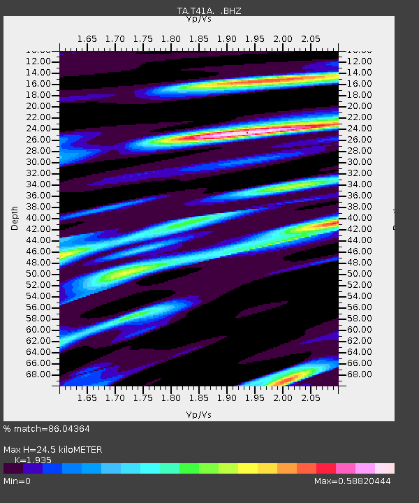
T41A Mountain View, MO, USA - Earthquake Result Viewer
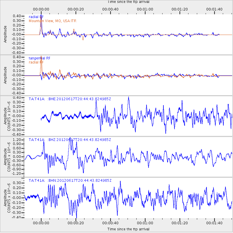
Earthquake location: Near East Coast Of Honshu, Japan
Earthquake latitude/longitude: 38.9/141.8
Earthquake time(UTC): 2012/06/17 (169) 20:32:20 GMT
Earthquake Depth: 36 km
Earthquake Magnitude: 6.0 MB, 5.9 MS, 6.3 MW, 6.4 MW
Earthquake Catalog/Contributor: WHDF/NEIC
Network: TA USArray Transportable Network (new EarthScope stations)
Station: T41A Mountain View, MO, USA
Lat/Lon: 37.04 N/91.76 W
Elevation: 366 m
Distance: 89.7 deg
Az: 40.089 deg
Baz: 321.108 deg
Ray Param: 0.041719913
Estimated Moho Depth: 24.5 km
Estimated Crust Vp/Vs: 1.93
Assumed Crust Vp: 6.53 km/s
Estimated Crust Vs: 3.375 km/s
Estimated Crust Poisson's Ratio: 0.32
Radial Match: 86.04364 %
Radial Bump: 368
Transverse Match: 63.220154 %
Transverse Bump: 400
SOD ConfigId: 460165
Insert Time: 2013-02-11 21:22:37.018 +0000
GWidth: 2.5
Max Bumps: 400
Tol: 0.001

Signal To Noise

ChannelStoNSTALTA
TA:T41A: :BHZ:20120617T20:44:43.824985Z7.23602154.609681E-76.370463E-8
TA:T41A: :BHN:20120617T20:44:43.824985Z2.42472051.14027365E-74.7027015E-8
TA:T41A: :BHE:20120617T20:44:43.824985Z2.85211321.3575588E-74.7598352E-8
Arrivals
Ps3.6 SECOND
PpPs11 SECOND
PsPs/PpSs14 SECOND