You are here: Home > Network List > TA - USArray Transportable Network (new EarthScope stations) Stations List
> Station P41A Barry, Barry, IL, USA > Earthquake Result Viewer
P41A Barry, Barry, IL, USA - Earthquake Result Viewer
| Earthquake location: |
Near East Coast Of Honshu, Japan |
| Earthquake latitude/longitude: |
38.9/141.8 |
| Earthquake time(UTC): |
2012/06/17 (169) 20:32:20 GMT |
| Earthquake Depth: |
36 km |
| Earthquake Magnitude: |
6.0 MB, 5.9 MS, 6.3 MW, 6.4 MW |
| Earthquake Catalog/Contributor: |
WHDF/NEIC |
|
| Network: |
TA USArray Transportable Network (new EarthScope stations) |
| Station: |
P41A Barry, Barry, IL, USA |
| Lat/Lon: |
39.67 N/91.06 W |
| Elevation: |
215 m |
|
| Distance: |
88.0 deg |
| Az: |
38.015 deg |
| Baz: |
321.501 deg |
| Ray Param: |
0.042851545 |
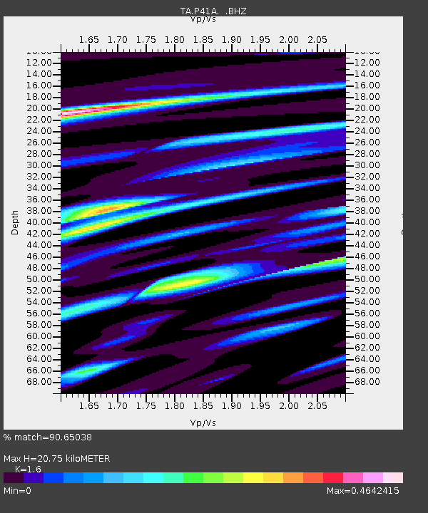
| Estimated Moho Depth: |
20.75 km |
| Estimated Crust Vp/Vs: |
1.60 |
| Assumed Crust Vp: |
6.498 km/s |
| Estimated Crust Vs: |
4.061 km/s |
| Estimated Crust Poisson's Ratio: |
0.18 |
|
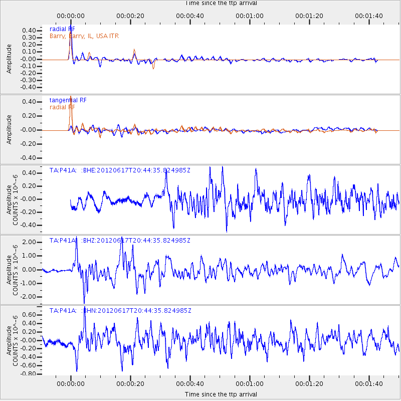
| Radial Match: |
90.65038 % |
| Radial Bump: |
355 |
| Transverse Match: |
70.92787 % |
| Transverse Bump: |
400 |
| SOD ConfigId: |
460165 |
| Insert Time: |
2013-02-11 21:23:58.403 +0000 |
| GWidth: |
2.5 |
| Max Bumps: |
400 |
| Tol: |
0.001 |
|
Signal To Noise
| Channel | StoN | STA | LTA |
| TA:P41A: :BHZ:20120617T20:44:35.824985Z | 10.675885 | 9.662676E-7 | 9.0509374E-8 |
| TA:P41A: :BHN:20120617T20:44:35.824985Z | 4.8345037 | 3.1477245E-7 | 6.5109575E-8 |
| TA:P41A: :BHE:20120617T20:44:35.824985Z | 2.94326 | 2.02778E-7 | 6.8895716E-8 |
| Arrivals |
| Ps | 2.0 SECOND |
| PpPs | 8.1 SECOND |
| PsPs/PpSs | 10 SECOND |


