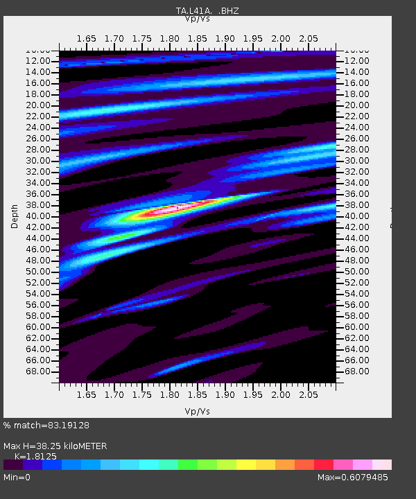
L41A Preston, IA, USA - Earthquake Result Viewer

Earthquake location: Near East Coast Of Honshu, Japan
Earthquake latitude/longitude: 38.9/141.8
Earthquake time(UTC): 2012/06/17 (169) 20:32:20 GMT
Earthquake Depth: 36 km
Earthquake Magnitude: 6.0 MB, 5.9 MS, 6.3 MW, 6.4 MW
Earthquake Catalog/Contributor: WHDF/NEIC
Network: TA USArray Transportable Network (new EarthScope stations)
Station: L41A Preston, IA, USA
Lat/Lon: 42.08 N/90.50 W
Elevation: 238 m
Distance: 86.4 deg
Az: 36.19 deg
Baz: 321.78 deg
Ray Param: 0.044030163
Estimated Moho Depth: 38.25 km
Estimated Crust Vp/Vs: 1.81
Assumed Crust Vp: 6.53 km/s
Estimated Crust Vs: 3.603 km/s
Estimated Crust Poisson's Ratio: 0.28
Radial Match: 83.19128 %
Radial Bump: 400
Transverse Match: 72.155426 %
Transverse Bump: 400
SOD ConfigId: 460165
Insert Time: 2013-02-11 21:24:02.809 +0000
GWidth: 2.5
Max Bumps: 400
Tol: 0.001

Signal To Noise

ChannelStoNSTALTA
TA:L41A: :BHZ:20120617T20:44:28.024998Z11.8348628.2059904E-76.933744E-8
TA:L41A: :BHN:20120617T20:44:28.024998Z2.56858062.2283567E-78.67544E-8
TA:L41A: :BHE:20120617T20:44:28.024998Z1.80951561.413083E-77.809179E-8
Arrivals
Ps4.9 SECOND
PpPs16 SECOND
PsPs/PpSs21 SECOND