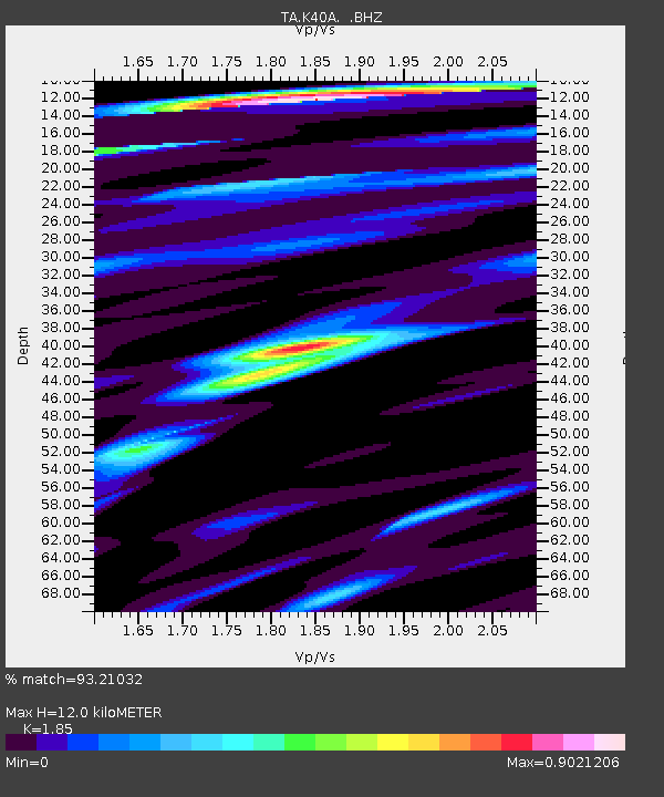
K40A Colesburg, IA, USA - Earthquake Result Viewer

Earthquake location: Near East Coast Of Honshu, Japan
Earthquake latitude/longitude: 38.9/141.8
Earthquake time(UTC): 2012/06/17 (169) 20:32:20 GMT
Earthquake Depth: 36 km
Earthquake Magnitude: 6.0 MB, 5.9 MS, 6.3 MW, 6.4 MW
Earthquake Catalog/Contributor: WHDF/NEIC
Network: TA USArray Transportable Network (new EarthScope stations)
Station: K40A Colesburg, IA, USA
Lat/Lon: 42.70 N/91.14 W
Elevation: 274 m
Distance: 85.6 deg
Az: 36.173 deg
Baz: 321.348 deg
Ray Param: 0.04458672
Estimated Moho Depth: 12.0 km
Estimated Crust Vp/Vs: 1.85
Assumed Crust Vp: 6.53 km/s
Estimated Crust Vs: 3.53 km/s
Estimated Crust Poisson's Ratio: 0.29
Radial Match: 93.21032 %
Radial Bump: 400
Transverse Match: 76.054405 %
Transverse Bump: 400
SOD ConfigId: 460165
Insert Time: 2013-02-11 21:24:14.590 +0000
GWidth: 2.5
Max Bumps: 400
Tol: 0.001

Signal To Noise

ChannelStoNSTALTA
TA:K40A: :BHZ:20120617T20:44:24.175022Z15.7122169.1412085E-75.8178987E-8
TA:K40A: :BHN:20120617T20:44:24.175022Z4.41388273.2174123E-77.2893016E-8
TA:K40A: :BHE:20120617T20:44:24.175022Z3.73605852.5047365E-76.7042215E-8
Arrivals
Ps1.6 SECOND
PpPs5.1 SECOND
PsPs/PpSs6.7 SECOND