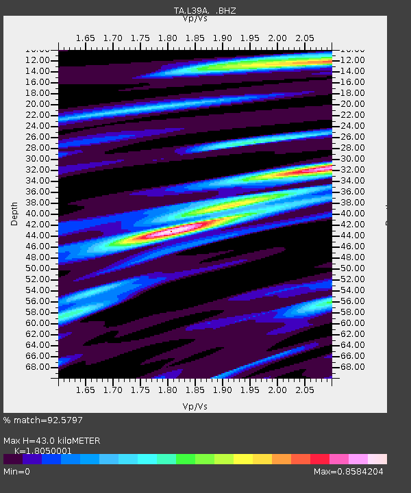
L39A Vinton, IA, USA - Earthquake Result Viewer
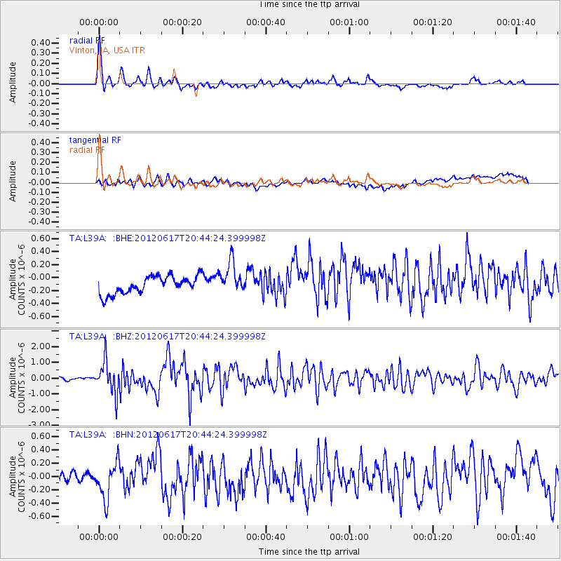
Earthquake location: Near East Coast Of Honshu, Japan
Earthquake latitude/longitude: 38.9/141.8
Earthquake time(UTC): 2012/06/17 (169) 20:32:20 GMT
Earthquake Depth: 36 km
Earthquake Magnitude: 6.0 MB, 5.9 MS, 6.3 MW, 6.4 MW
Earthquake Catalog/Contributor: WHDF/NEIC
Network: TA USArray Transportable Network (new EarthScope stations)
Station: L39A Vinton, IA, USA
Lat/Lon: 42.12 N/92.00 W
Elevation: 261 m
Distance: 85.7 deg
Az: 37.034 deg
Baz: 320.834 deg
Ray Param: 0.04455294
Estimated Moho Depth: 43.0 km
Estimated Crust Vp/Vs: 1.81
Assumed Crust Vp: 6.53 km/s
Estimated Crust Vs: 3.618 km/s
Estimated Crust Poisson's Ratio: 0.28
Radial Match: 92.5797 %
Radial Bump: 400
Transverse Match: 59.04403 %
Transverse Bump: 400
SOD ConfigId: 460165
Insert Time: 2013-02-11 21:24:35.422 +0000
GWidth: 2.5
Max Bumps: 400
Tol: 0.001

Signal To Noise

ChannelStoNSTALTA
TA:L39A: :BHZ:20120617T20:44:24.399998Z12.5525291.0373253E-68.263875E-8
TA:L39A: :BHN:20120617T20:44:24.399998Z3.42423082.8023936E-78.1840085E-8
TA:L39A: :BHE:20120617T20:44:24.399998Z1.88009832.5056772E-71.3327373E-7
Arrivals
Ps5.4 SECOND
PpPs18 SECOND
PsPs/PpSs23 SECOND