P42A Winchester, IL, USA - Earthquake Result Viewer
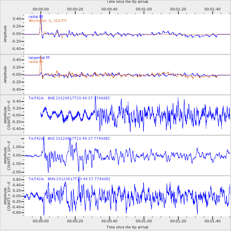
Earthquake location: Near East Coast Of Honshu, Japan
Earthquake latitude/longitude: 38.9/141.8
Earthquake time(UTC): 2012/06/17 (169) 20:32:20 GMT
Earthquake Depth: 36 km
Earthquake Magnitude: 6.0 MB, 5.9 MS, 6.3 MW, 6.4 MW
Earthquake Catalog/Contributor: WHDF/NEIC
Network: TA USArray Transportable Network (new EarthScope stations)
Station: P42A Winchester, IL, USA
Lat/Lon: 39.59 N/90.34 W
Elevation: 197 m
Distance: 88.4 deg
Az: 37.635 deg
Baz: 321.945 deg
Ray Param: 0.042544454
Estimated Moho Depth: 20.5 km
Estimated Crust Vp/Vs: 2.09
Assumed Crust Vp: 6.498 km/s
Estimated Crust Vs: 3.105 km/s
Estimated Crust Poisson's Ratio: 0.35
Radial Match: 88.62084 %
Radial Bump: 400
Transverse Match: 55.642815 %
Transverse Bump: 400
SOD ConfigId: 460165
Insert Time: 2013-02-11 21:25:02.583 +0000
GWidth: 2.5
Max Bumps: 400
Tol: 0.001

Signal To Noise

ChannelStoNSTALTA
TA:P42A: :BHZ:20120617T20:44:37.774998Z14.85590658.448999E-75.6873E-8
TA:P42A: :BHN:20120617T20:44:37.774998Z3.77352142.469781E-76.5450294E-8
TA:P42A: :BHE:20120617T20:44:37.774998Z2.08327051.9661307E-79.4377114E-8
Arrivals
Ps3.5 SECOND
PpPs9.6 SECOND
PsPs/PpSs13 SECOND