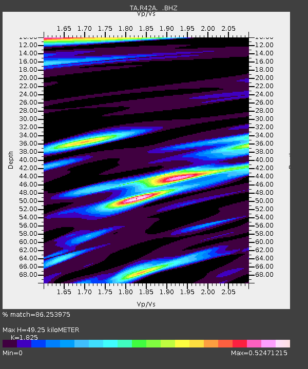
R42A Luebbering, MO, USA - Earthquake Result Viewer
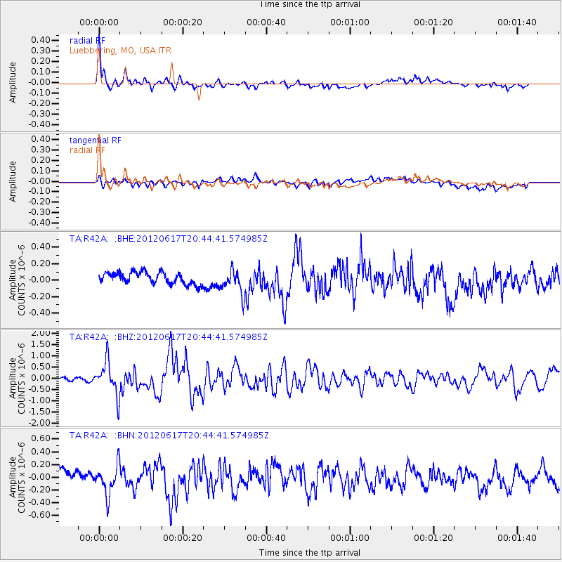
Earthquake location: Near East Coast Of Honshu, Japan
Earthquake latitude/longitude: 38.9/141.8
Earthquake time(UTC): 2012/06/17 (169) 20:32:20 GMT
Earthquake Depth: 36 km
Earthquake Magnitude: 6.0 MB, 5.9 MS, 6.3 MW, 6.4 MW
Earthquake Catalog/Contributor: WHDF/NEIC
Network: TA USArray Transportable Network (new EarthScope stations)
Station: R42A Luebbering, MO, USA
Lat/Lon: 38.28 N/90.79 W
Elevation: 218 m
Distance: 89.2 deg
Az: 38.717 deg
Baz: 321.685 deg
Ray Param: 0.04195002
Estimated Moho Depth: 49.25 km
Estimated Crust Vp/Vs: 1.83
Assumed Crust Vp: 6.498 km/s
Estimated Crust Vs: 3.56 km/s
Estimated Crust Poisson's Ratio: 0.29
Radial Match: 86.253975 %
Radial Bump: 400
Transverse Match: 65.0366 %
Transverse Bump: 400
SOD ConfigId: 460165
Insert Time: 2013-02-11 21:25:48.657 +0000
GWidth: 2.5
Max Bumps: 400
Tol: 0.001

Signal To Noise

ChannelStoNSTALTA
TA:R42A: :BHZ:20120617T20:44:41.574985Z11.1304717.726789E-76.9420146E-8
TA:R42A: :BHN:20120617T20:44:41.574985Z2.24455932.3883192E-71.0640481E-7
TA:R42A: :BHE:20120617T20:44:41.574985Z2.17698071.5388353E-77.0686674E-8
Arrivals
Ps6.4 SECOND
PpPs21 SECOND
PsPs/PpSs27 SECOND