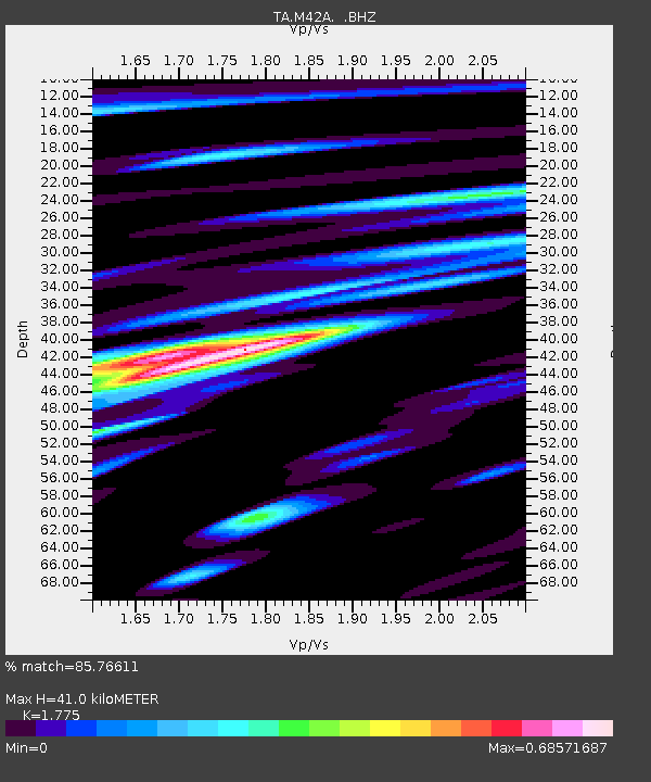
M42A Sheffield, IL, USA - Earthquake Result Viewer
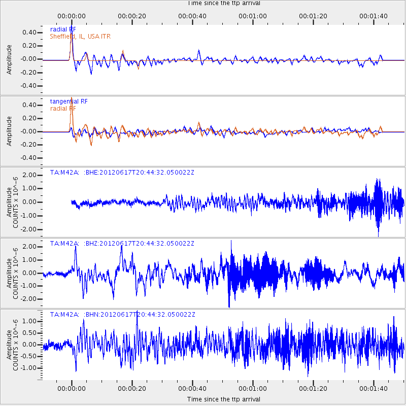
Earthquake location: Near East Coast Of Honshu, Japan
Earthquake latitude/longitude: 38.9/141.8
Earthquake time(UTC): 2012/06/17 (169) 20:32:20 GMT
Earthquake Depth: 36 km
Earthquake Magnitude: 6.0 MB, 5.9 MS, 6.3 MW, 6.4 MW
Earthquake Catalog/Contributor: WHDF/NEIC
Network: TA USArray Transportable Network (new EarthScope stations)
Station: M42A Sheffield, IL, USA
Lat/Lon: 41.45 N/89.76 W
Elevation: 212 m
Distance: 87.2 deg
Az: 36.135 deg
Baz: 322.268 deg
Ray Param: 0.043423608
Estimated Moho Depth: 41.0 km
Estimated Crust Vp/Vs: 1.77
Assumed Crust Vp: 6.498 km/s
Estimated Crust Vs: 3.661 km/s
Estimated Crust Poisson's Ratio: 0.27
Radial Match: 85.76611 %
Radial Bump: 400
Transverse Match: 63.913513 %
Transverse Bump: 400
SOD ConfigId: 460165
Insert Time: 2013-02-11 21:26:16.515 +0000
GWidth: 2.5
Max Bumps: 400
Tol: 0.001

Signal To Noise

ChannelStoNSTALTA
TA:M42A: :BHZ:20120617T20:44:32.050022Z7.03511678.10407E-71.1519454E-7
TA:M42A: :BHN:20120617T20:44:32.050022Z3.94938544.476597E-71.133492E-7
TA:M42A: :BHE:20120617T20:44:32.050022Z2.07016972.8417614E-71.3727191E-7
Arrivals
Ps5.0 SECOND
PpPs17 SECOND
PsPs/PpSs22 SECOND