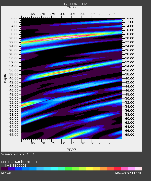
H39A Augusta, WI, USA - Earthquake Result Viewer

Earthquake location: Near East Coast Of Honshu, Japan
Earthquake latitude/longitude: 38.9/141.8
Earthquake time(UTC): 2012/06/17 (169) 20:32:20 GMT
Earthquake Depth: 36 km
Earthquake Magnitude: 6.0 MB, 5.9 MS, 6.3 MW, 6.4 MW
Earthquake Catalog/Contributor: WHDF/NEIC
Network: TA USArray Transportable Network (new EarthScope stations)
Station: H39A Augusta, WI, USA
Lat/Lon: 44.68 N/91.28 W
Elevation: 345 m
Distance: 84.0 deg
Az: 35.012 deg
Baz: 321.143 deg
Ray Param: 0.045734152
Estimated Moho Depth: 19.5 km
Estimated Crust Vp/Vs: 1.81
Assumed Crust Vp: 6.571 km/s
Estimated Crust Vs: 3.63 km/s
Estimated Crust Poisson's Ratio: 0.28
Radial Match: 89.264534 %
Radial Bump: 400
Transverse Match: 72.85254 %
Transverse Bump: 400
SOD ConfigId: 460165
Insert Time: 2013-02-11 21:27:17.643 +0000
GWidth: 2.5
Max Bumps: 400
Tol: 0.001

Signal To Noise

ChannelStoNSTALTA
TA:H39A: :BHZ:20120617T20:44:16.10001Z11.931746.983671E-75.8530198E-8
TA:H39A: :BHN:20120617T20:44:16.10001Z2.2008061.584054E-77.197609E-8
TA:H39A: :BHE:20120617T20:44:16.10001Z3.25201541.9729646E-76.066898E-8
Arrivals
Ps2.5 SECOND
PpPs8.1 SECOND
PsPs/PpSs11 SECOND