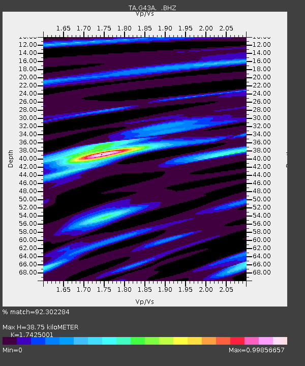
G43A Wallace, MI, USA - Earthquake Result Viewer
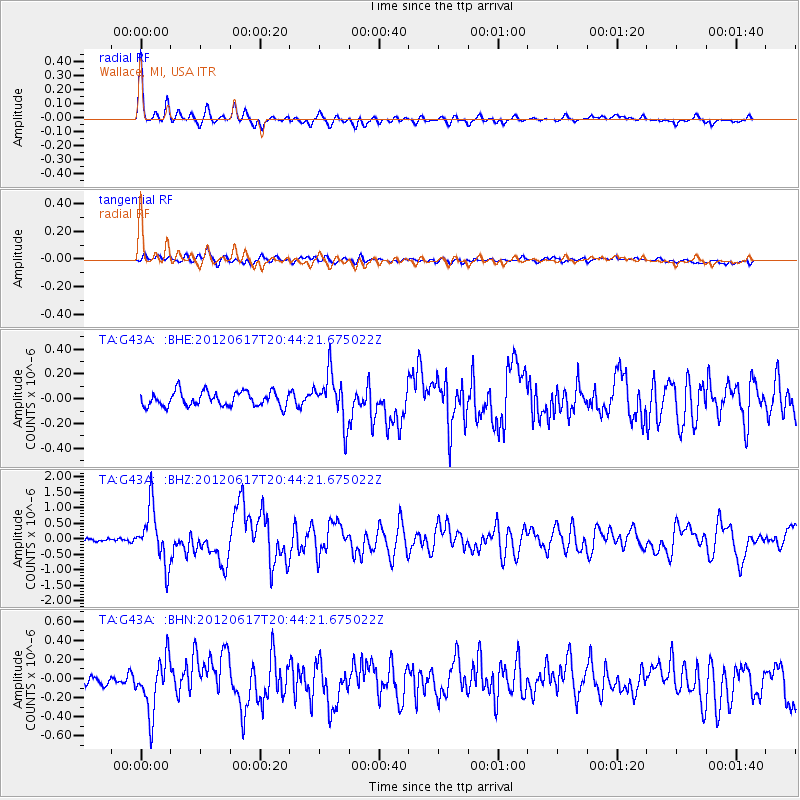
Earthquake location: Near East Coast Of Honshu, Japan
Earthquake latitude/longitude: 38.9/141.8
Earthquake time(UTC): 2012/06/17 (169) 20:32:20 GMT
Earthquake Depth: 36 km
Earthquake Magnitude: 6.0 MB, 5.9 MS, 6.3 MW, 6.4 MW
Earthquake Catalog/Contributor: WHDF/NEIC
Network: TA USArray Transportable Network (new EarthScope stations)
Station: G43A Wallace, MI, USA
Lat/Lon: 45.26 N/87.69 W
Elevation: 213 m
Distance: 85.1 deg
Az: 32.628 deg
Baz: 323.452 deg
Ray Param: 0.044948332
Estimated Moho Depth: 38.75 km
Estimated Crust Vp/Vs: 1.74
Assumed Crust Vp: 6.53 km/s
Estimated Crust Vs: 3.748 km/s
Estimated Crust Poisson's Ratio: 0.25
Radial Match: 92.302284 %
Radial Bump: 306
Transverse Match: 63.89895 %
Transverse Bump: 400
SOD ConfigId: 460165
Insert Time: 2013-02-11 21:29:29.099 +0000
GWidth: 2.5
Max Bumps: 400
Tol: 0.001

Signal To Noise

ChannelStoNSTALTA
TA:G43A: :BHZ:20120617T20:44:21.675022Z10.950858.827246E-78.060786E-8
TA:G43A: :BHN:20120617T20:44:21.675022Z5.4732712.8285956E-75.168017E-8
TA:G43A: :BHE:20120617T20:44:21.675022Z3.38672691.9515213E-75.7622636E-8
Arrivals
Ps4.5 SECOND
PpPs16 SECOND
PsPs/PpSs20 SECOND