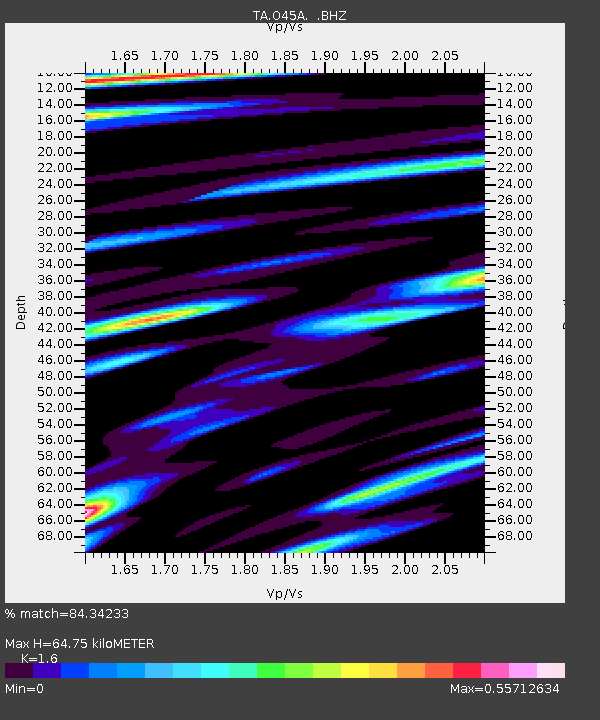
O45A Potomac, IL, USA - Earthquake Result Viewer
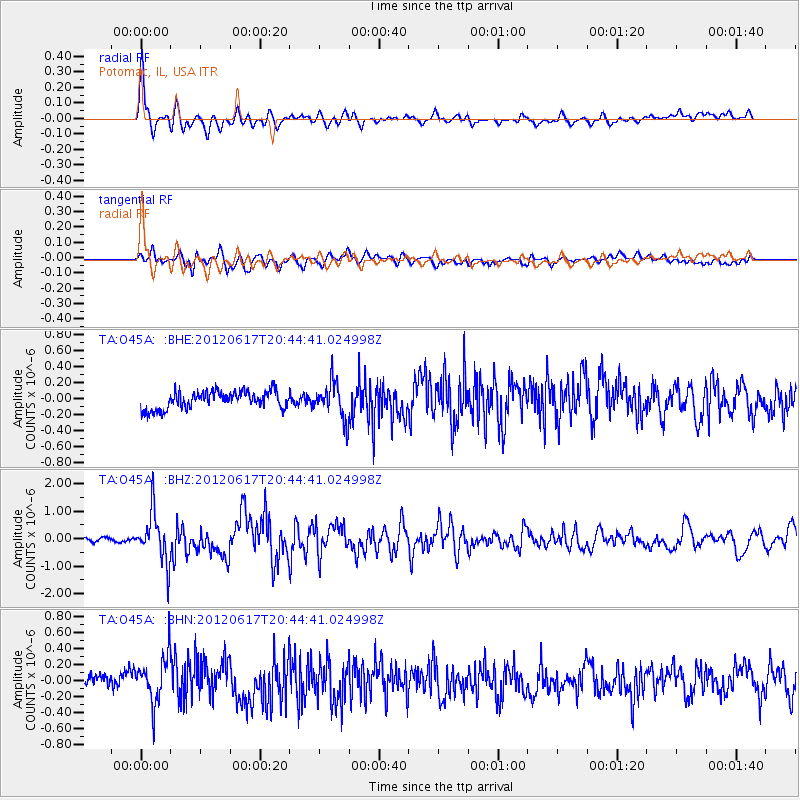
Earthquake location: Near East Coast Of Honshu, Japan
Earthquake latitude/longitude: 38.9/141.8
Earthquake time(UTC): 2012/06/17 (169) 20:32:20 GMT
Earthquake Depth: 36 km
Earthquake Magnitude: 6.0 MB, 5.9 MS, 6.3 MW, 6.4 MW
Earthquake Catalog/Contributor: WHDF/NEIC
Network: TA USArray Transportable Network (new EarthScope stations)
Station: O45A Potomac, IL, USA
Lat/Lon: 40.25 N/87.72 W
Elevation: 208 m
Distance: 89.1 deg
Az: 35.63 deg
Baz: 323.577 deg
Ray Param: 0.04203405
Estimated Moho Depth: 64.75 km
Estimated Crust Vp/Vs: 1.60
Assumed Crust Vp: 6.498 km/s
Estimated Crust Vs: 4.061 km/s
Estimated Crust Poisson's Ratio: 0.18
Radial Match: 84.34233 %
Radial Bump: 400
Transverse Match: 73.244545 %
Transverse Bump: 400
SOD ConfigId: 460165
Insert Time: 2013-02-11 21:31:20.227 +0000
GWidth: 2.5
Max Bumps: 400
Tol: 0.001

Signal To Noise

ChannelStoNSTALTA
TA:O45A: :BHZ:20120617T20:44:41.024998Z12.5385128.971773E-77.155373E-8
TA:O45A: :BHN:20120617T20:44:41.024998Z3.02556512.9607716E-79.785847E-8
TA:O45A: :BHE:20120617T20:44:41.024998Z2.0878112.2742648E-71.0893059E-7
Arrivals
Ps6.1 SECOND
PpPs25 SECOND
PsPs/PpSs31 SECOND