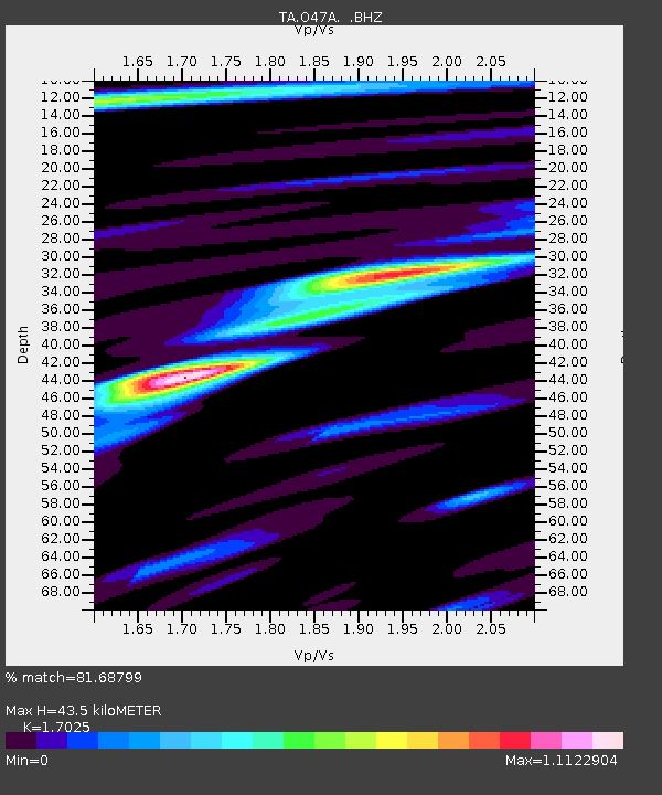
O47A Sheridan, IN, USA - Earthquake Result Viewer
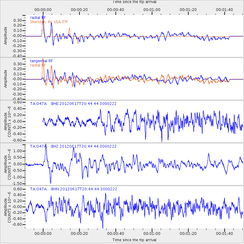
Earthquake location: Near East Coast Of Honshu, Japan
Earthquake latitude/longitude: 38.9/141.8
Earthquake time(UTC): 2012/06/17 (169) 20:32:20 GMT
Earthquake Depth: 36 km
Earthquake Magnitude: 6.0 MB, 5.9 MS, 6.3 MW, 6.4 MW
Earthquake Catalog/Contributor: WHDF/NEIC
Network: TA USArray Transportable Network (new EarthScope stations)
Station: O47A Sheridan, IN, USA
Lat/Lon: 40.24 N/86.17 W
Elevation: 278 m
Distance: 89.8 deg
Az: 34.677 deg
Baz: 324.566 deg
Ray Param: 0.041712333
Estimated Moho Depth: 43.5 km
Estimated Crust Vp/Vs: 1.70
Assumed Crust Vp: 6.498 km/s
Estimated Crust Vs: 3.816 km/s
Estimated Crust Poisson's Ratio: 0.24
Radial Match: 81.68799 %
Radial Bump: 400
Transverse Match: 78.73167 %
Transverse Bump: 400
SOD ConfigId: 460165
Insert Time: 2013-02-11 21:31:32.989 +0000
GWidth: 2.5
Max Bumps: 400
Tol: 0.001

Signal To Noise

ChannelStoNSTALTA
TA:O47A: :BHZ:20120617T20:44:44.300022Z10.2296076.8573684E-76.703453E-8
TA:O47A: :BHN:20120617T20:44:44.300022Z2.26142842.0848151E-79.219019E-8
TA:O47A: :BHE:20120617T20:44:44.300022Z2.25788071.8401164E-78.1497504E-8
Arrivals
Ps4.8 SECOND
PpPs18 SECOND
PsPs/PpSs23 SECOND