You are here: Home > Network List > TA - USArray Transportable Network (new EarthScope stations) Stations List
> Station R45A Skylar, Fairfield, IL, USA > Earthquake Result Viewer
R45A Skylar, Fairfield, IL, USA - Earthquake Result Viewer
| Earthquake location: |
Near East Coast Of Honshu, Japan |
| Earthquake latitude/longitude: |
38.9/141.8 |
| Earthquake time(UTC): |
2012/06/17 (169) 20:32:20 GMT |
| Earthquake Depth: |
36 km |
| Earthquake Magnitude: |
6.0 MB, 5.9 MS, 6.3 MW, 6.4 MW |
| Earthquake Catalog/Contributor: |
WHDF/NEIC |
|
| Network: |
TA USArray Transportable Network (new EarthScope stations) |
| Station: |
R45A Skylar, Fairfield, IL, USA |
| Lat/Lon: |
38.29 N/88.28 W |
| Elevation: |
143 m |
|
| Distance: |
90.4 deg |
| Az: |
37.142 deg |
| Baz: |
323.232 deg |
| Ray Param: |
0.041669242 |
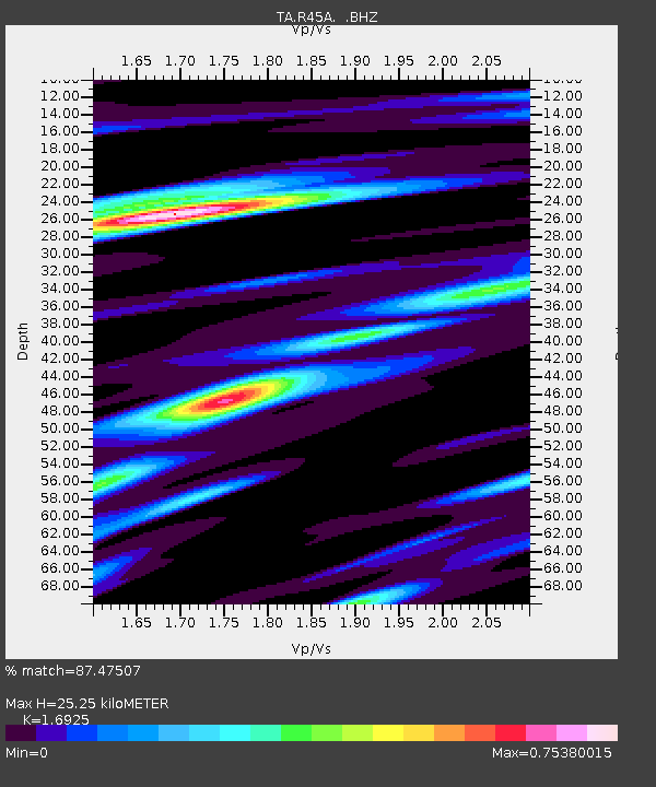
| Estimated Moho Depth: |
25.25 km |
| Estimated Crust Vp/Vs: |
1.69 |
| Assumed Crust Vp: |
6.444 km/s |
| Estimated Crust Vs: |
3.807 km/s |
| Estimated Crust Poisson's Ratio: |
0.23 |
|
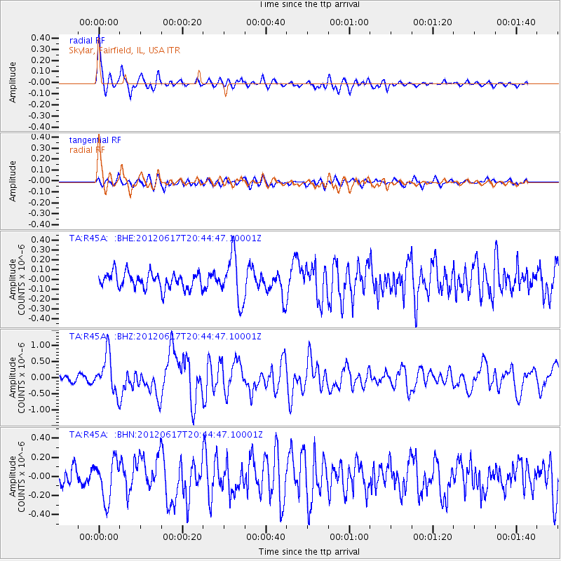
| Radial Match: |
87.47507 % |
| Radial Bump: |
400 |
| Transverse Match: |
62.21418 % |
| Transverse Bump: |
400 |
| SOD ConfigId: |
460165 |
| Insert Time: |
2013-02-11 21:32:20.698 +0000 |
| GWidth: |
2.5 |
| Max Bumps: |
400 |
| Tol: |
0.001 |
|
Signal To Noise
| Channel | StoN | STA | LTA |
| TA:R45A: :BHZ:20120617T20:44:47.10001Z | 9.450778 | 6.173256E-7 | 6.532009E-8 |
| TA:R45A: :BHN:20120617T20:44:47.10001Z | 2.75066 | 2.0982614E-7 | 7.6282106E-8 |
| TA:R45A: :BHE:20120617T20:44:47.10001Z | 3.0112824 | 2.3714303E-7 | 7.8751505E-8 |
| Arrivals |
| Ps | 2.8 SECOND |
| PpPs | 10 SECOND |
| PsPs/PpSs | 13 SECOND |


