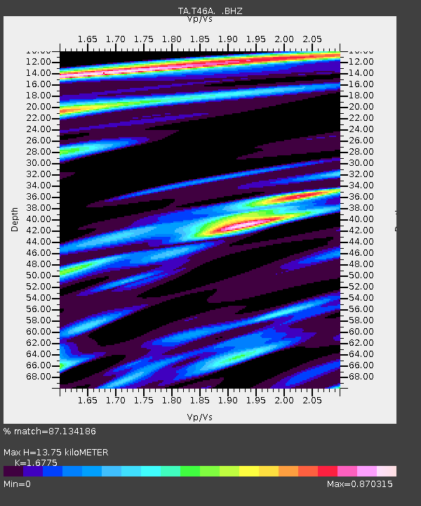
T46A Princeton, KY, USA - Earthquake Result Viewer

Earthquake location: Near East Coast Of Honshu, Japan
Earthquake latitude/longitude: 38.9/141.8
Earthquake time(UTC): 2012/06/17 (169) 20:32:20 GMT
Earthquake Depth: 36 km
Earthquake Magnitude: 6.0 MB, 5.9 MS, 6.3 MW, 6.4 MW
Earthquake Catalog/Contributor: WHDF/NEIC
Network: TA USArray Transportable Network (new EarthScope stations)
Station: T46A Princeton, KY, USA
Lat/Lon: 37.04 N/87.89 W
Elevation: 169 m
Distance: 91.6 deg
Az: 37.641 deg
Baz: 323.458 deg
Ray Param: 0.04157292
Estimated Moho Depth: 13.75 km
Estimated Crust Vp/Vs: 1.68
Assumed Crust Vp: 6.444 km/s
Estimated Crust Vs: 3.841 km/s
Estimated Crust Poisson's Ratio: 0.22
Radial Match: 87.134186 %
Radial Bump: 400
Transverse Match: 71.03408 %
Transverse Bump: 400
SOD ConfigId: 460165
Insert Time: 2013-02-11 21:32:44.870 +0000
GWidth: 2.5
Max Bumps: 400
Tol: 0.001

Signal To Noise

ChannelStoNSTALTA
TA:T46A: :BHZ:20120617T20:44:52.574985Z5.1460114.971468E-79.66082E-8
TA:T46A: :BHN:20120617T20:44:52.574985Z2.58065941.6901865E-76.549437E-8
TA:T46A: :BHE:20120617T20:44:52.574985Z2.17857651.3008825E-75.9712505E-8
Arrivals
Ps1.5 SECOND
PpPs5.6 SECOND
PsPs/PpSs7.1 SECOND