You are here: Home > Network List > TA - USArray Transportable Network (new EarthScope stations) Stations List
> Station X49A Woodville, AR, USA > Earthquake Result Viewer
X49A Woodville, AR, USA - Earthquake Result Viewer
*The percent match for this event was below the threshold and hence no stack was calculated.
| Earthquake location: |
Near East Coast Of Honshu, Japan |
| Earthquake latitude/longitude: |
38.9/141.8 |
| Earthquake time(UTC): |
2012/06/17 (169) 20:32:20 GMT |
| Earthquake Depth: |
36 km |
| Earthquake Magnitude: |
6.0 MB, 5.9 MS, 6.3 MW, 6.4 MW |
| Earthquake Catalog/Contributor: |
WHDF/NEIC |
|
| Network: |
TA USArray Transportable Network (new EarthScope stations) |
| Station: |
X49A Woodville, AR, USA |
| Lat/Lon: |
34.51 N/86.33 W |
| Elevation: |
182 m |
|
| Distance: |
94.4 deg |
| Az: |
38.098 deg |
| Baz: |
324.347 deg |
| Ray Param: |
$rayparam |
*The percent match for this event was below the threshold and hence was not used in the summary stack. |
|
| Radial Match: |
75.34289 % |
| Radial Bump: |
400 |
| Transverse Match: |
57.425217 % |
| Transverse Bump: |
400 |
| SOD ConfigId: |
460165 |
| Insert Time: |
2013-02-11 21:33:45.261 +0000 |
| GWidth: |
2.5 |
| Max Bumps: |
400 |
| Tol: |
0.001 |
|
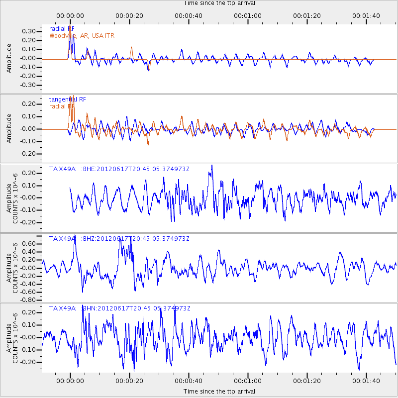
Signal To Noise
| Channel | StoN | STA | LTA |
| TA:X49A: :BHZ:20120617T20:45:05.374973Z | 3.6531785 | 3.2663542E-7 | 8.9411294E-8 |
| TA:X49A: :BHN:20120617T20:45:05.374973Z | 3.1033874 | 1.10176195E-7 | 3.5501916E-8 |
| TA:X49A: :BHE:20120617T20:45:05.374973Z | 1.1340716 | 7.241174E-8 | 6.385112E-8 |
| Arrivals |
| Ps | |
| PpPs | |
| PsPs/PpSs | |


