You are here: Home > Network List > TA - USArray Transportable Network (new EarthScope stations) Stations List
> Station X48A Hartselle, AL, USA > Earthquake Result Viewer
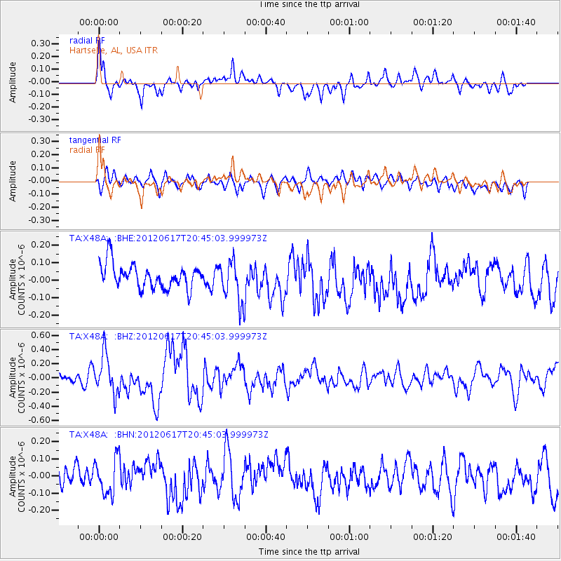
X48A Hartselle, AL, USA - Earthquake Result Viewer
*The percent match for this event was below the threshold and hence no stack was calculated.
| Earthquake location: |
Near East Coast Of Honshu, Japan |
| Earthquake latitude/longitude: |
38.9/141.8 |
| Earthquake time(UTC): |
2012/06/17 (169) 20:32:20 GMT |
| Earthquake Depth: |
36 km |
| Earthquake Magnitude: |
6.0 MB, 5.9 MS, 6.3 MW, 6.4 MW |
| Earthquake Catalog/Contributor: |
WHDF/NEIC |
|
| Network: |
TA USArray Transportable Network (new EarthScope stations) |
| Station: |
X48A Hartselle, AL, USA |
| Lat/Lon: |
34.45 N/87.05 W |
| Elevation: |
180 m |
|
| Distance: |
94.1 deg |
| Az: |
38.616 deg |
| Baz: |
323.903 deg |
| Ray Param: |
$rayparam |
*The percent match for this event was below the threshold and hence was not used in the summary stack. |
|
| Radial Match: |
72.21057 % |
| Radial Bump: |
400 |
| Transverse Match: |
63.801743 % |
| Transverse Bump: |
400 |
| SOD ConfigId: |
460165 |
| Insert Time: |
2013-02-11 21:33:57.331 +0000 |
| GWidth: |
2.5 |
| Max Bumps: |
400 |
| Tol: |
0.001 |
|
Signal To Noise
| Channel | StoN | STA | LTA |
| TA:X48A: :BHZ:20120617T20:45:03.999973Z | 3.7107935 | 2.8328628E-7 | 7.634116E-8 |
| TA:X48A: :BHN:20120617T20:45:03.999973Z | 1.7972345 | 1.0682896E-7 | 5.9440747E-8 |
| TA:X48A: :BHE:20120617T20:45:03.999973Z | 1.7840858 | 1.2369368E-7 | 6.93317E-8 |
| Arrivals |
| Ps | |
| PpPs | |
| PsPs/PpSs | |


